KACIKE: Journal of Caribbean Amerindian History and Anthropology
![]()
![]()
![]()
![]()
![]()
![]()
![]()
|
This article has been reproduced with the kind permission of the author. The citation information for the original article is: Seidemann, Ryan M. 2001. The Bahamian Problem in Florida Archaeology: Oceanographic Perspectives on the Issue of Pre-Columbian Contact. The Florida Anthropologist, 54(1):4-23. The pagination from the original source has been preserved below. The Bahamian Problem in Florida Archaeology: Oceanographic Perspectives on the Issue of Pre-Columbian Contact Ryan M. Seidemann Introduction The origins and relationships of the prehistoric inhabitants of the Bahamas and those of the southeastern United States have been the subject of much debate for over a hundred years. This study examines the oceanographic implications of the Florida Current on prehistoric contact between these two regions The paper also considers previously published oceanographic literature in conjunction with the current anthropological evidence from the Caribbean and the south- eastern United States, and inferences for ocean voyaging from the Pacific to suggest probable areas that may yield evidence of contact. Historic accounts have alluded to the fact that the Lucayan inhabitants of the prehistoric Bahamas were aware of land to the northwest (i.e., Florida), but this popular conception may have originated from Spanish misinterpretations or misrepresentations as had occurred concerning the Fountain of Youth, typically associated with Ponce de Leon. Peck (1992; 1993) casts significant doubt on the motivations of this myth for Spanish explorations which led to the discovery of the Florida mainland. No mention of the Fountain of Youth exists in Ponce de Leon's charter for the exploration of Birnini (Peck1992:115). Descriptions of land to the north of the Bahamas by the time of the Spanish conquest of Florida may have been the result of historic movements of native groups fleeing the Spanish or some of the unsanctioned voyages of Spanish exploration (Milanich1995: 107). Weber (1992) suggests that this myth was of ancient European origin rather than Caribbean, casting doubt on the native populations' knowledge of Florida as related in the popular Fountain of Youth myths (eg. Weddle 1985). Due to the problematic nature of the Fountain of Youth myth (outlined in Arana 1965; Peck 1992, 1993: Weber 1992) this piece of popular folklore should riot be considered as incontrovertible evidence that the Lucayan Ta�nos (the pre-Columbian inhabitants of the Bahamas) were knowledgeable about the Florida mainland during prehistoric times. Watters(1982: 2) argues for the importance of archaeologists to be cognizant of the dynamic ocean processes that have affected past human populations. Although earlier studies (Cruxent and Rouse 1969; Evans and Meggars 1976; Sleight 1965) emphasized the importance of the oceanography and climatology of the Caribbean in understanding prehistoric contact. no detailed examination of these factors, as yet, has been undertaken. This study reviews oceanographic data and underscores the necessity for anthropologists to consider oceanographic research when interpreting movements of past peoples in an insular environment. This paper attempts to fill the gap in the research of the contact issue by taking a "seaward': approach to the late prehistoric record of the Bahamas, as suggested by Watters (1981. 1982) and Watters and Rouse (1989) Much of the decision to focus this paper on Bahamas-to-Florida contact and not Florida-to-Bahamas contact is based on this "seaward perspective of Watters' (1982), which basically suggests that the ocean-focused Lucayans instead of the riverine-focused Florida Indians would have been more likely to initiate contact. The Florida Indians might have seen the ocean as a barrier rather than a highway. In contrast, the Lucayans, or any ocean-going inhabitants of the insular Caribbean. would not likely have seen the vast expanses of the ocean as a barrier, but rather as a highway upon which they transported their trade goods from one island to the next (much as the modem Bahamians do). The expanse of the ocean to the northwest of the Bahamas likely appeared the same to the Lucayans as the large ocean gaps between their own islands. In addition to the perceived barrier of the open ocean, the Florida Current, apart of the Gulf Stream, probably constituted a true barrier as it flowed in a northeasterly direction between Florida and the Bahamas. Additionally, the prehistoric inhabitants of the Bahamian archipelago were a highly mobile seafaring group, establishing over-water trading networks throughout the islands (Watters 1997). The rapid dispersal of peoples throughout the whole of the West Indies begs the question, "Why stop at the northernmost Bahamian islands?" Following the suggestions of Watters (1982). I have incorporated the available scholarship on the prehistoric voyaging and migrations in the Pacific. Unlike the archaeological record of the Bahamas. the Pacific offers a long chronology from which to interpret motivations for migrations from one island to the next, archaeological evidence for migrations. and navigational techniques.
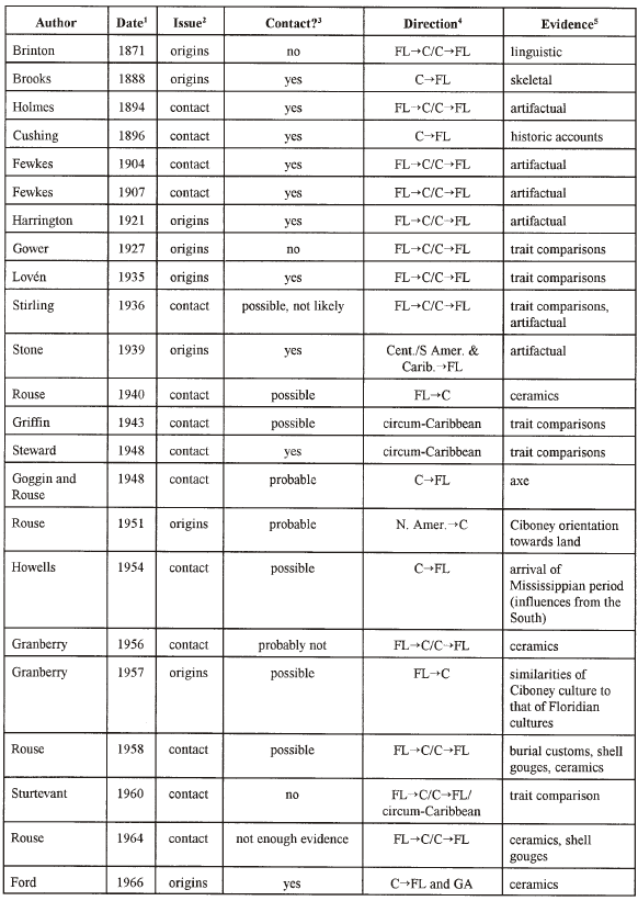
The past century yielded a vast amount of
scientific and avocational theorizing on the origins and migrations of the
prehistoric inhabitants of the Caribbean (see Table 1 which provides the
essential information regarding these publications). Many of the scholars
changed their opinions on the contact issue over time as more information became
available. ---end of page 4--- Table 1. Summary of previous research on
Caribbean-Florida contact ---end of page 5--- Table 1. Continued 
1 date of
publication More recent studies (Callaghan 1999; Elbow 1992; Rouse 1986; Wilson et al. 1998) have also examined the issue of Central American Caribbean contacts and migrations and suggest that the inhabitants of the Caribbean were capable ocean-going seafarers.
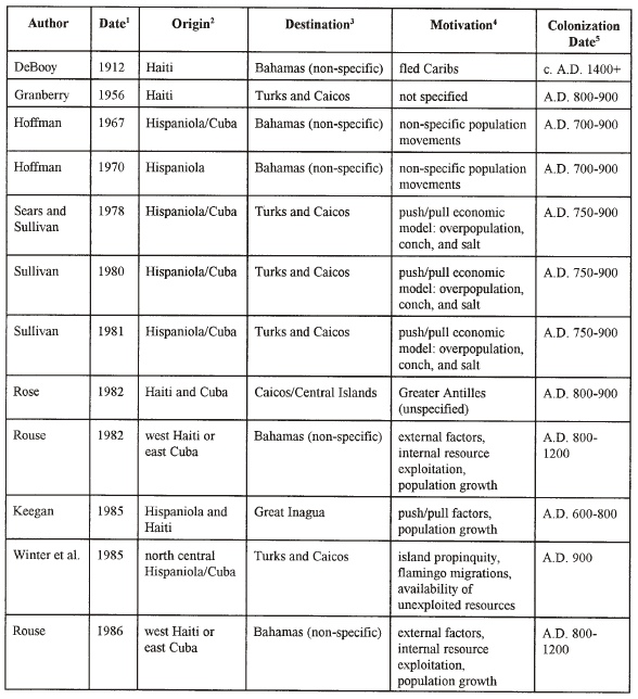
Several current hypotheses offer differing perspectives on
motivations for migration in the prehistoric Bahamas. These are buttressed by
older theories concerning motivations for prehistoric voyaging and information
from the Pacific, which is also relevant to the present study. The information
contained in Table 2 summarizes the publications dealing with the debate about
the motivations for the colonization of the Bahamas. Although this paper is not
specifically concerned with the initial colonization(s) of the Bahamian
archipelago, the possible motivations for these colonization activities may be
analogous to the motivations for possible Floridian contact. The majority of the
papers outlined in Table 2 suggest "push/pull" motivators for colonization (as
described by Lee 1966), most of which center around population
densities ---end of page 6--- pushing people out and resource exploitation pulling people away. Keegan (1985, 1992: 1997) suggests that the total population of the Bahamian islands was at least 40.000 at the time of European contact. Additionally, he adds that the northernmost islands (Grand Bahama, Great Abaco, and Andros) had been settled for some time when Columbus arrived in A.D. 1492. Even though the population expansion could have eventually created an economic "need," such as those described above, for migration to a new locale (i.e., Florida), the timing of such a model (i.e., late in the prehistoric period) makes it questionable whether or not such a necessity would have arisen prior to the arrival of the Europeans. Irwin's (1990:92) economic models for migration in the Pacific offer a useful analogy. He argues. based on archaeological reconnaissance and the analysis of radiocarbon dates. that the major migration events in the Pacific took place at the times of the lowest population densities. While traditional economic models are valid for suggesting a push/pull migration pattern. stressful economic conditions are not a prerequisite to force migration under Irwin's (1990) interpretation. Thus, although the late arrival of peoples in the northernmost Bahamian islands (ca. A.D. 1200) makes economic factors questionable (i.e., could they have depleted their resources, necessitating a migration, in such a short amount of time?) for migration to Florida, alternative possibilities would have allowed for almost immediate exploration following the colonization of these islands, thereby increasing the time available before the arrival of the Europeans. Keegan and Diamond (1987) suggest that the motivation for island colonization differs from that of exploration, whereby the migrants continued to explore new, unknown areas of ocean because of the expectation of finding new land. Under such a model, the orientation of the islands of the Caribbean (see Figure 1) provide a linear track which could have directed settlers along the islands and ultimately towards Florida. This model is part of the theory of autocatalysis, which states basically that the idea of a return voyage was an expected component of exploration (i.e., explorers did not set out on voyages of no return). Irwin (1989:176) initially doubted the validity of this model. based primarily on problems unique to Oceania. He now agrees that this type of voyaging was likely the primary method employed in prehistory (Irwin 1992). The remainder of this study attempts to determine whether the natural and technological factors present in the late prehistoric Bahamas were conducive to such contact. This author assumes (after Keegan 1992, 1997) that the northernmost Bahamian islands were settled at least 100 years prior to European contact: and that, based on most of the studies in Table 2. there were motivations for further colonization. What ---end of page 7---
Figure 2 These three vessels are after Callaghan (1999) and illustrate the types of Caribbean vessels discussed in the text ([a] the Florida Type-3 canoe [cf. Newsom and Purdy 1990]; [b] the Maya canoe; [c] the Warao canoe). I present here is an evaluation of the factors that could have impeded such migration.
The CaribbeanLittle primary evidence exists from the Caribbean on the appearance and design of prehistoric watercraft. Much of the knowledge of the prehistoric Caribbean is drawn from archaeological and historic contests of the surrounding areas (i.e., Maya area; Orinoco region; Florida) (Callaghan 1995, 1999). Only two archaeological examples of watercraft are known to exist from the Caribbean (one from Cuba and one from Andros Island in the Bahamas) (Callaghan and Schwabe 1999). Additionally, a brief description exists of a prehistoric canoe discovered in a Jamaican cave (Cundall 1894-5) and there is an unconfirmed report of one discovered in Trinidad (Callaghan, communication 1999). Several authors have examined Spanish Colonial evidence for clues as to the nature of watercraft in the Caribbean (Glazier 1991; Johnstone 1980: McKusick 1960; Sauer 1966). Although historic accounts are sometimes conflicting on this topic, it is unlikely that the Pre-Columbian inhabitants of the Caribbean possessed sail technology (Glazier 1991:152). McKusick (1960:5) states that vessels with sailing capabilities were recorded by most observers after A.D. 1650. He dismisses the presence of aboriginal sails by that late date as a result of European contact. While speculation still persists as to the presence or absence of sail technology, the majority of the evidence suggests that neither the Ta�no nor the Florida Indians possessed such technology prior to European contact (McKusick 1960; Newsom and Purdy 1990). Although, there are reports of voyages between Florida and Cuba during the historic period (Hann 1991); these sources are not very helpful because it is impossible to know what influence the European technology and knowledge had on such voyages. Based upon the accounts of Columbus and his associates (see Sauer 1966) regarding the size of Caribbean dugout canoes, some sort of construction beyond simply hollowing a single tree trunk was necessary. The length of the vessel which held seventy to eighty persons, as described by Columbus (McKusick 1960:8; see also Wilbert 1977:18), was not likely constructed out of a single piece of timber. Johnstone (1980:235) suggests that the canoe lengths described by Columbus and by Bernaldez (McKusick 1960) must have been accomplished by lashing on planks. McKusick (1960:7) and Johnstone (1980:235) agree that the lashing of planks with fiber would suggest an aboriginal origin of this practice rather than an imitation of the Europeans (which would have implied the use of a nail-like device), and that such technology was present prior to European contact. McKusick (1960:4) states that plank technology would allow for a more seaworthy craft. Unfortunately, archaeological evidence for the interpretation of West Indian watercraft is lacking (Leshikar 1996:19), forcing scholars to speculate based on scant historical accounts. While the dugout was, undoubtedly, the primary type of watercraft in use by the native populations at the time of Spanish contact (Leshikar 1996:19; Johnstone 1980:234), the specific design of dugout canoe is still unclear. Callaghan (1995, 1999) and Callaghan and Schwabe (1 999) have combined archaeological and documentary evidence from the Maya area, the Caribbean, the Orinoco region of South America, and Florida to reconstruct the appearance and seadaring capabilities of Caribbean watercraft. They conclude that the appearance of Taino canoes resembled the overhanging bow style canoe described by Newsom and Purdy (1990: 170-17 l) (see Figure 2). However, they note that a Lucayan canoe discovered in the Bahamas (Callaghan and Schwabe 1999) resembles vessels from the Orinoco region (e.g., Figure 2c). Evidence for the seacraft on the opposite side of the Straits of Florida is widely available. with a total of nearly 200 canoes known in existence from the waterways of Florida, spanning over 5,000 years (Newsom and Purdy 1990: 164). On the other hand, prehistoric contact from the North American mainland to the Bahamas is unlikely (as opposed to Bahamian-to-North American contact) due to adverse ocean currents and other factors. As with their Caribbean counterparts, the Floridian watercraft were dominated by dugout canoes, but these were mostly utilized for riverine transport. The early vessels were manufactured by hollowing tree trunks with fire, sometimes evidenced by a charred interior (Newsom and Purdy 1990:170). The overhanging bow style of the Type 3 examples of Newsom and Purdy (1990:170-171) closely resemble the Taino canoes described by Callaghan (1995: 184) (see Figure 2). In contrast to the Florida watercraft as described by Newsom and Purdy (1990) and Bullen and Brooks (1967), which were likely created for use in riverine environments, Callaghan (1999) and Callaghan and Schwabe (1999) note that the Caribbean vessels were designed for open ocean ---end of page
8--- Table 2. Summary of
theories regarding migrations in the Caribbean navigation. the width of the Caribbean vessels, which exceeds that of the Floridian seacraft would have provided added stabilization on the open ocean. The Caribbean canoes are also thought to have been more maneuverable than their Floridian counterparts (Callaghan 1999: 15). The Pacific Numerous experimental voyages
employing prehistoric vessel and navigation technology have been accomplished in
the Pacific area (e.g. Finney 1997, 1988; Finney et al. 1986, 1989; Gladwin,
1970; Lewis 1972) these studies, as well as larger studies of Pacific seafaring
are relevant for comparative study with other island archipelagoes (Keegan 1993:
246), including the Caribbean. ---end of page
9--- 1 date of publication of these vessels, such as single and double-outrigger canoes, were sailing vessels and not comparable to the Caribbean watercraft. However: bark boats and rafts may very well have been used in prehistoric Caribbean (cf., Nicholson 197a), however these types of vessels would have become waterlogged quickly and would not have been useful in open ocean voyaging (Doran 1981; Nicholson 197a). the Pacific dugouts are probably the most closely analogous vessels to those used in the prehistoric Caribbean for interisland voyaging.
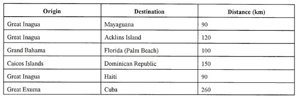
With little evidence for the construction of watercraft is available for the West Indies, various authors (Callaghan 1995: Johnstone 1980; McKusick 1960) contend that the Taino probably possessed the technology for long distance ocean travel. Whether they were able to reach the North American mainland is, therefore, an issue of environmental factors, assuming that the technology existed. Most of the gaps between the islands in the archipelagoes of the
West Indies are short enough to see the next island or intermediate keys (Keegan
1992:25-6). The currents between these islands and keys remain at a consistent
calm level throughout most of the Caribbean. On the other hand, the distances
between the Bahamian islands and Florida (the closest North American landmass)
are as long as the longest ---end of page 10--- Figure 3
Map of the showing the major ocean currents as they move through the Caribbean. The Florida Current moves to the west of the Greater Antilles and then continues between Florida and Cuba and then joins the Antilles Current as it passes through the Straits of Florida. water gaps between the West Indian islands (see Table 3). Additionally, no keys lie between the Bahamian Islands and the mainland. Another mitigating factor with regard to the possibility of Caribbean contact with Florida is the Florida Current (a portion of the Gulf Stream), which, as Bullen (1974: 158) contends, constituted a barrier for cultural diffusion. The Gulf Stream begins south of the Gulf of Mexico in the Yucatan Channel (see Figure 3). The wind patterns of the globe directly reflect on the motions of the surface ocean currents (Davis 1977:94), and the Gulf Stream is created by a westerly drag of winds caused by the rotation of the earth and a thermohaline return flow from the South Atlantic (Chave ct al.1997; Gaskell 1973; Schmitz and Richardson 1991). The thermohaline flow is a deep-ocean, density-driven circulation created by a combination of factors. This circulation is caused partly by convection of warm, salty water as it reaches the poles and cools. As the salty water cools, its buoyancy decreases, and the water sinks Secondly, brine rejection also causes water to sink as freezing water "rejects" salt and increases the density of non-freezing waters. This process occurs continuously (with seasonal variations) with density differences "pushing" large amounts of water around the deep oceans (Cronin 1999:27). The winds which help push the current from above, are the result of the Coriolis effect, which is a deflection of moving particles, in this case air, to the right in the Northern Hemisphere, creating a clockwise circulation around the subtropical high in the Atlantic. The Coriolis effect is due to the eastward rotation of the Earth (Davis 1977; Wells 1998). By the time the currents pass through the Straits of Florida they are much like a river 64 km wide and 6 10 m deep flowing out of the Gulf of Mexico into the Atlantic Ocean (National Oceanic and Atmospheric Administration [NOAA] 1985). This is corroborated by Gaskell(1973: 13) and Sanford (1982:621) The Straits of Florida are a deep channel between the Florida peninsula and the Bahama Banks. The topography of the ocean floor in the Straits resembles a canyon that drops steeply from the small continental shelf off the Atlantic Coast of Florida to a depth of as much as approximately 780 m before steeply rising again on the Bahamian side of the channel (Defense Mapping Agency [DMA] 1996). This 'wall of water' separating the West Indies and Florida passes between Cuba and the Bahamian archipelago to the south and the Florida peninsula to the north (NOAA 1985:Fi g. 1). Iselin (1936) and Fofonoff (1981) define the Florida
Current as all northward-moving waters with velocities exceeding 10 cm s-' (1 m
per second) which begin in a line south of the Tortugas and extend past Cape
Hatteras where the current moves off the ---end of page
11--- Table 3. Distances between
Bahamian Islands and the North American mainland (After Keegan 1985:
26) continental shelf. The water travels through the Straits of Florida with an average velocity of 8 km/h, "discharging 100 billion tons of water per hour" (NOAA 1985:l). Certainly, this natural phenomenon presents the most significant barrier to Floridian-Caribbean contact. Historic sources also report on the strength of the current through the Straits of Florida and the difficulty of sailing through it. The Florida Current was reported by Antonio de Herrera y Tordesillas as observed during Ponce de Leon's 1513 voyage. "A current was observed which, though they had a good wind, they could not stem" (NOAA 1985:2). Another account from McKinnen (1804:268-9) states that the progress of his party from Grand Bahama along the Florida coast was "rapid." He also comments that he knows of no other area where the navigation of the ocean is more difficult than along the south shores of Florida. "So very fallacious and irresistible are the cross currents and eddies, that it often happens whilst vessels are steering in one course they are carried nearly in an opposite direction" (McKimen 1804:269). Indeed, the current was strong enough that McKinnen (1804:270) states that from their departure from Grand Bahama, the Florida Current carried his party to the area of Charleston, SC, in a "short time." The logical question now is, to what degree would this 'river in the ocean' have actually influenced the travels of aboriginal Caribbeans? Although the previous sources
give some insight into the nature of historic seafaring in the Gulf Stream, the
question remains whether the Florida Current helped or hindered individuals
attempting to cross the Straits of Florida prehistorically. Oceanographic
investigation is of the velocity and transport of the current through the
Straits of Florida may shed some light on this question. Fofonoff (1981:139)
states that "the Florida Current emerges as the part of the Gulf Stream that is
best documented, analyzed. and understood" (see also Schmitz and McCartney
1993). Sanford (1 982:636-7) states that the measurements of seasonal
fluctuations and amplitude of the Florida Current are in agreement whether using
measurements Data from recent investigations at various depths into the physical properties of the Florida Current provide insight into prehistoric conditions. Niiler and Richardson (1973) determined the mean transport of the Florida Current to be 30x106m3s1. This figure, which translates to an overall transport of thirty trillion cubic meters of water per decisecond (tenth of a second) and is referred to as 30 Sv (Sverdrups); measures the total transport of a fluid through a confined passage. Such a figure is derived from repetitive vertical profiles of the velocity from the surface to the ocean bottom where each measurement at differing depths is standardized by a constant velocity (Wells 1998:220). While the transport is not a measure of the speed of the current, this research provides clues to the seasonal variability of the current, as well as other phenomena. Niiler and Richardson (1973:
144) suggest an annual cycle deviation of 30 Sv fron the mean of 30 Sv through
the Straits of Florida at the point or their investigations (a line
between Miami and Bimini). While others have reported different amounts of
transport through the Straits (e.g. x=32 Sv by Larsen 1992; x=30 Sv Schmitz and
McCartney 1993; n=30.5 Sv by Schott et al. 1988; x=27.71 Sv by Welsh 1996), this
is likely due to the various locations from which the observations were made.
Additionally, none differed significantly from the 30 Sv mean transport reported
by Niiler and Richardson (1973). The seasonal variation originally identified by
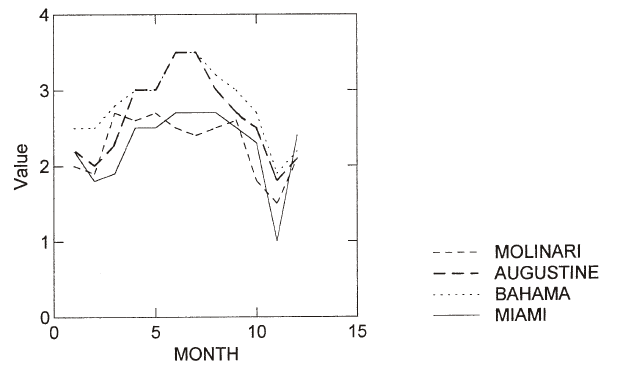
Niiler ---end of page 12--- Figure 4 This graph illustrates the general trends of the flow of the Florida Current as discussed in the text. The sources, including surface flow data from the Atlas of Pilot Charts (Defense Mapping Agency 1994) and Molinari and Leaman (l987), show a clear minimum of flow speed around the months of October to December each year. The Molinari and Leaman data are referred to on the graph as "Molinari." The Defense Mapping Agency data are denoted by the closest land locations to the points where the data were derived from the adjacent Florida Current on the maps (i.e., Augustine=St. Augustine; Bahama=West End, Grand Bahama Island; Miami=Miami). and Richardson (1973) may provide a basis for interpreting the ideal time of the year for the occurrence of Bahamas to Florida travel. Numerous authors Gee et al. 1985; Schott and Zantopp 1985: Schott ct al. 1988) have documented a significant annual drop in the transport, and by inference a decrease in the speed of the flow (Molinari and Leaman 1987). of the Florida Current around the months of October and November (see Figure 4). Schott et al. (1988: 1212) report an early winter low around 20 Sv, while Schott and Zantopp (1985:308) report an early winter low of 25.4 Sv. This winter low could have equated to less treacherous traveling conditions for prehistoric peoples (see also Sleight 1965:228). However, a mid-summer high in transport volume and surface current strength, which possibly constituting more treacherous conditions, may have been exploited to push the Lucayans along the Florida Atlantic coastline. Under such a model, the winter low could have been employed for decreased resistance for return voyages to the Bahamas. The extent to which the motion of the Florida Current affected the possibility of prehistoric contact between the Bahamas and Florida may be inferred from the following study. Horvath and Finney (1976) conducted a series of paddling
experiments specifically targeting the issue of human endurance and capability
in prehistoric Pacific travel off the California coast and in the waters near
the Hawaiian islands. Although these tests were carried out for use in studies
of Pacific travel, the sail-less canoe and crew size likely approximates that of
the small Caribbean vessels discussed in the historic sources. The vessel of the
Horvath and Finney (1976:48) experiments was 12.2 m in length and carried a crew
of twelve men of varying paddling experience. Horvath and Finney (1976:49) found
that the realistic maintainable speed of the paddlers was 4 knots (kts) (7.4
km/h) . This rate of travel is insufficient to paddle 'upstream' against the
stronger flow of the Gulf Stream (which may be up to 5.5 kts). Maul et al.
(1991) show that the surface speeds of the Florida Current are much stronger (up
to 5.5 knots) near the Florida coast than for the rest of the current (which
ranges from 1.2 to 3.3 knots, on average). The fatigue of the 52 nautical mile
(nmi) (96.3 km) experimental journey took a significant toll on the test
subjects. The men lost a considerable amount of body weight even though food and
water were readily available in the vessel. While the subjective observations of
the test subjects were that, given sufficient rest, food. and water, they could
keep up the trek for several consecutive days. Horvath and Finney (1976:53)
state that the material needs of the ---end of page
13--- travelers would necessitate a large vessel. Horvath and Finney (1976:54) comment that the results of this study suggest that "a crew of physically fit and experienced paddlers" could paddle a canoe more than 50 nmi (92.5 km) in two days, a distance extremely close to that between Grand Bahama and Palm Beach, Florida (approximately 100 kin). However, travelers leaving from Grand Bahama may have had an easier time of paddling than Horvath and Finney 's (1976) test subjects. as they would have the pushing assistance of the Florida Current. Conversely, individuals departing from Florida, as per the results of Horvath and Finney (1976), would likely be incapable of sustaining the necessary speed to stem the Florida Current down its axis. The results of Horvath and Finney's (1 976) experiments seem to make the possibility of contact between Florida and the Bahamas unlikely due to the strength of the Florida Current, but not contact from the Bahamas to Florida. The strength of the current as it moves up the Atlantic coast equals or exceeds (depending on the season) the maximum sustainable speeds of the paddlers in the Horvath and Finney (1976) study. In addition to the Horvath and Finney (1976) experimental study, some information can be extracted from Blanchard's (I 999) study on near shore voyaging. Blanchard states that vessels with a crew of two or more would have been hard pressed to paddle into winds in excess of twelve knots. Such a factor would be a consideration for return voyages against the Florida Current (even without adverse winds, Blanchard's 1999 study supports the difficulty of paddling against strong current). The Florida Current makes for a difficult situation when considering return voyages of the Lucayans or voyages of Florida Indians to the Bahamas. The strength of this current likely constituted a considerable hindrance to such movements (as demonstrated above). However. Irwin (1992) argues against voyages of no return. He states that death or the possibility of not returning from excursions would have been significant deterrents to prehistoric voyagers. I argue that the oceanic-oriented Lucayans may have been able to negotiate the strong currents in the Straits of Florida using large crews and exploiting the variations in the surface currents and winds across the Straits. Such a strategy may have included riding the Florida Current northward and paddling in a northeasterly direction to stem the near-shore currents (the strongest in the Straits) and then turning in a southeasterly direction and paddling against the weaker (1.2-3.3 kt) eastern margin of the Florida Current for the remainder of the return voyage. The smaller canoes from Florida (Newsom and Purdp 1993) probably did not have the capacity for large enough crews to overcome the current. This contention returns to the earlier mentioned dichotomy of riverine versus oceanic orientations of seafaring capabilities. While the Lucayan Taino were likely accustomed to the conditions of operating a craft on the open ocean, due to centuries of experience from interisland trading and other types of ocean-going travel, the Floridian groups were more likely suited to riverine, marsh. and near-shore aqueous environments. The differences in the skills necessary to negotiate these divergent environments suggests that, out of necessity, the Lucayans, with their oceanic knowledge, would be the more likely initiates of contact across the treacherous Florida Current than their riverine focused Floridian counterparts. If prehistoric voyagers had departed the northern Bahamian islands in search of land to the north, it is probable that they were not able to cross the Florida Current directly to southern Florida, but rather that they would have been swept up in the current and dragged along the east coast of Florida. In any case, the natural direction of exploration from the Bahamas would likely be in a northwesterly direction due to the roughly northwest-southeast orientation of that island archipelago. This orientation of the Bahamian archipelago might have suggested to the prehistoric Lucayans that more uninhabited islands were located to the northwest of the northernmost Bahamian islands. Rather than contact between the inhabitants of southern Florida such as the Calusa or the Tequesta, it seems more probable that if any contact was made between the Lucayans and the North American aborigines it would have begun further north, perhaps in the areas of the Jeaga (Palm Beach County) or Ais (St. Lucie, Indian River, and Brevard Counties) or the Timucua of the St. Johns River and present day St. Augustine and Jacksonville: or possibly along the coasts of Georgia or South Carolina.
Although the sail-less canoes, which are believed to be the most common mode of long-distance transportation in the pre-Columbian Bahamas, would not typically be in danger of adverse sailing conditions created by strongwinds, winds of 12 knots or stronger may still have presented difficulty for small crews attempting to paddle a sail-less canoe (Blanchard 1999). Wind strengths reported on maps from the DMA (1994) were compared against Blanchard's (1999) benchmark of 12 kts as difficult rowing conditions. This benchmark (12 kts) falls within the force 4 strength winds on the Beaufort Scale of Wind Strength. The Beaufort Scale, divided into 12 "forces'' ranging from call11 to hurricane strength conditions (Rousmaniere 1989:132), is the standard measure used to present average wind strengths on the DMA maps (1994). The majority of the wind strengths in the area of the Straits of Florida (including the Floridian East Coast and the Northern Bahamian islands) arc reported to average Beaufort Scale force 4 (1 1-16 kts) year-round. Because wind strength in the Straits is relatively constant, direction is a more important factor. For travel to have occurred from the Bahamas to Florida, low frequencies of winds from the North (Southerly winds) and the West (Easterly winds) would have been favorable. The mid-summer months (June/July) exhibit the best such conditions. Although the winds from the North are low in frequency during the mid-summer, this is the time at which the Florida Current is at its strongest (and the Straits most treacherous for watercraft). However, the Lucayans may have chosen to exploit this extra push from the Florida Current during the summer months: coupled with the reduced fre-
quency of resistance from Southerly winds to propel them from the
northernmost Bahamas to the United States mainland. If such a strategy were
employed, the Lucayans could have exploited the reduced flow of the Florida
Current and the increased frequency of Southerly winds during the months of
October or November to accomplish the return voyages to the Bahamas (a necessary
component of autocatalytic voyaging suggested by Twin 1992). One factor which
would aid Bahamas to Florida voyages and hinder Florida to Bahamas voyages are
the Prevailing Westerlies. i.e., the high frequencies of westward blowing trade
winds which are common in the Caribbean. Such winds, if sustained and
powerful (12+ kts), might push travelers in the Florida Current towards the
Florida mainland. The frequency of these winds in the Straits of Florida are
highly variable and although they are not at the peak of their occurrence in
October or November (during the Florida Current calms), a moderate frequency of
these winds exceed 11 kts (Beaufort Scale force 4 to 5) at this time (DMA 1994).
Such conditions might have significantly hampered efforts for Florida to Bahamas
voyaging or return voyages for Lucayans who had landed in Florida.
Sea-Level Change and the Flow of the Florida Current The importance of the sea-level stand on both sides of the Straits of Florida to the current issue is twofold: increases in the sea-level may obscure coastal sites that yield evidence of contact and the sea-level has a direct correlation to the transport volume through the Straits Therefore, a clear understanding of the late prehistoric sea-level stands in the northern Bahamas and along the Florida Atlantic coast should lead to a clearer picture of site locations and the natural barriers to contact. Although rising sea-levels over the past 12,000 years haw been demonstrated to obscure archaeological sites on the Gulf Coast of Florida (see Dorsey 1997) a widespread inundation of sites on the Atlantic coast of Florida is highly unlikely due lo the morphological differences of the continental shelf on either side of the Flondan peninsula. As was stated earlier the Straits of Flonda constitute a steep drop in the depth of the ocean floor not far from the visible coastline of Florida on thc Atlantic side of the peninsula (see Figure5 ) Therefore the amount of land when compared to the Gulf side of the peninsula, which has been inundated over the past 1000 years (the reasonable earliest date of possible contact) is probably negligible. This is not, however, meant to undermine the importance of such sea-level studies of the Atlantic coast. Rather it is a generalization which may be oversimplified for a few individual areas, as there are some submerged sites off of the Atlantic Coast of Florida (e.g., 8SL17), however, they are too early to be relevant to the contact issue. Watters (1981; 1992) advocates the examination of episodic sea-level fluctuations for the purposes of identifying and interpreting submerged sites, especially in the Caribbean. Mitchell and Keegan (1987), however. do not find evidence that significant numbers of sites are obscured by sea-level changes in the Bahamas. They state that evidence from coastline studies suggest a change in sea-level in the Bahamas with 50cm of the present sea-level stand for the past 1400 years Valdes (1994, 1996) also supports the unlikely probability for the sea-level changes worldwide to have affected the identification of sites in the Bahamas. In recent years, archaeologists hale focused on sea-level changes on the Gulf Coast of Florida (see Dorsey 1997, Walker et al 1994, 1995) as have other scholars in the Bahamas (see Valdes 1994, 1996). These studies demonstrate that the familiar Holocene model for a smooth, constant sea-level rise over the past 12,000 years (e.g. Fairbridge1974, 1984) is an average curve which may obscure certain details important to archaeologists, but not necessarily relevant to the geologists who created the model (Walker et al. 1994: 161). Such nuances, which may have been overlooked in the Holocene model, may also play a significant role in the issue of Bahamian-Floridian contact; they may obscure minor fluctuations in sea-levels that could have influenced the transport of the Florida Current. Maul et al. (1985) report a linear correlation (r2=0.93, ∞=0.05 for Jupiter; r2=0.74, ∞=0.05 for Miami; r2=0.94, ∞=0.05 between Jupiter and the Bahamas) between minute sea-level fluctuations and the transport of the Florida Current. The statistical results reported above are from regression tests which examine the relationship of the transport volume of the Florida Current to the sea-level stand at the time of measurement. These data show a strong correlation between sea-level and transport volume (the closer the r2 statistic is to 1.0 the more one variable explains the other) (Maul et al. 1985). So, in this case sea-level changes can account for 93%, 74%, and 94% respectively for each of the three locations measured at the 95% confidence level (∞=0.05). Maul et al. (1985.307) suggest that the overall transport of the Florida Current can be inferred from measurements of sea-level with an error of only � l x 106m3s (less than 1Sv). Thus, as the sea-levels drop, so do the transport volume and the surface speeds. Episodic sea-level fluctuation is considered for the Gulf Coast of Florida by Colquhoun et al. (1995). Walker et al. (1994), and Walker et al. (1995), and may hold some significance for the Florida Current. Several investigators (Alexander 1974; Fairbridge 1974, 1984: Robbin 1984) have noted a general trend of increase in sea-levels during the most recent part of the Holocene (c. 6.000 B.P. to present) in southern Florida. Although not a constant increas,. Robbin (1984:441) notes that the sea-level stand has never been higher than present during the Holocene. This increase, noted as +1.2 mm/yr from 7,000-2,000 years B.P. and +0.3 mm/yr from 2,000 B.P.- present by Robbin (1984:437) (a trend generally agreed upon by Fairbridge 1984:431), may have resulted in lower transport means on the other side of the peninsula. and presumably somewhat easier traveling conditions for the Pre-Columbian inhabitants of the Bahamas (also suggested by Nicholson 1976b for the rest of the Caribbean).
Unfortunately, no universally accepted diagnostic remains or other archaeological evidence has been found that links the ---end of page
15--- This map (after
NOAA 1998) illustrates the basic topography of the area around the Straits of
Florida. The shaded areas indicate the shallower continental shelves. The
numbers indicate depth soundings (in meters) in the Straits of Florida. The
large arrows indicate the general flow of the Florida Current through the
Straits of Florida. It can be stated with reasonable certainty that the indigenous populations of the Caribbean (the Lucayan Taino in particular) inhabited the northernmost islands of the Bahamas before the arrival of the Europeans in 1492. Many of the ---end of page 16--- scholars examining motivations for migration and colonization in the Bahamas argue for push/pull motivators. Such an approach likely necessitates long lapses of time for resource depletion and/or population growth to force migration. If the Lucayans had arrived very late in the prehistoric period to the northernmost Bahamian islands, such a push/pull perspective, if true, would probably negate the possibility of migration attempts to North America. Simply. there just would not have been enough time for the push/pull factors to impel a migration before the arrival of Columbus. However, under these models the possibility of contact is not ruled out entirely. Keegan (1985) suggests that exploration parties likely voyaged from the home island in advance of push/pull factors necessitating the search for new land. These exploratory expeditions may have reached the North American mainland in search or new lands prior to the arrival of the Europeans or the onset of demographic and or economic need for such knowledge. Other scholars (Irwin 1992; Keegan and Diamond 1987) suggest that although push/pull factors may have existed, such consequences were not necessary to initiate migrations. With the northernmost Bahamas inhabited prior to the arrival of Europeans, the North American mainland was ripe for exploration with the Bahamas as a staging point. The migration theories concerning insular populations suggest that, even under the restrictive push/pull models, the potential existed for at least exploration (if not colonization) in a northerly direction prior to European contact. If contact occurred, it may have simply been too late in the prehistoric period for colonies to be established (due to decimation of the native populations by the Europeans). This possibility, coupled with the established indigenous populations in Florida, a problem not likely encountered in newly found lands in the Bahamas, may have constituted a considerable deterrent to permanent settlement. Although not identical in design, similar watercraft from Pacific contexts, as well as computer simulations of prehistoric voyages from the Pacific (Irwin 1992; Irwin et al. 1990; Levison et al. 1973) and the Caribbean (Callaghan 1999) support the seaworthiness of the Caribbean watercraft. The study by Horvath and Finney (1976) also suggests that human paddlers could have endured the conditions necessary to cross the Straits of Florida from the Bahamas to the United States mainland. In contrast to earlier studies (e.g. Sharp 1964), it is probable that the aboriginal inhabitants of the Caribbean (like those of the Pacific) had an intimate understanding of the natural clues to way-finding on the open ocean. As previously stated, based on the work of Horvath and Finney (1976), the flow of the Florida Current (when considering northward travel) was manageable all year, with the months of October- November the least treacherous for navigating the Florida Current due to the reduced flows. Additionally, the Atlantic cyclone season begins to slow down during the late Fall. Active cyclone seasons could have enhanced the danger of navigating the Florida Current during the mid-summer months, even though, in general, wind conditions were more favorable during this period. The archaeological evidence is minimal for contact between the Bahamas and the North American mainland Why, then, if such contact was likely, based on technology and environment, is there such a dearth of archaeological evidence? Based on the flow of the Florida Current, those looking for evidence of contact may be looking in the wrong place. It is unlikely that the Lucayans would have been able to cross the Florida Current at a 90 degree angle to the flow, or even close to that trajectory. This fact alone rules out much of southern Florida as a possible landing location. It is likely if such contact did occur, that the Florida Current would have pushed the Lucayans along the coast for some distance. I suggest that possible landing points for such voyages would not begin until the Melbourne/Cape Canaveral area (which would help explain the Antillean axe head reported near Gainesville by Goggin and Rouse 1948). Historic accounts of sailings from the Bahamas also support this location as a likely destination in Florida. Additionally, while it would seem likely that ceramic vessels would have been employed to transport foodstuffs on long voyages, it is also likely that they served the same purpose on return voyages. Therefore, I do not suggest ceramic technologies as the best method for identifying Bahamian/Floridian contact. In order to identify considerable ceramic samples in the archaeological record, more long term contacts, rather than sporadic encounters, are necessary, and such sustained contact is unlikely. I suggest that small, portable trade items may hold the artifactual key to interpreting prehistoric contact. Items such as trade beads, pendants, or small zemis may be logical diagnostic items to be looking for along the southeastern United States Atlantic coast. Small items (pendants), collected by De Booy, are described in such a context on Bimini by Granberry (1957:380). Although these items do not support the possibility of Floridian/Bahamian contact, they do demonstrate the probable remains of brief visitations: small, portable objects. Instances of the difficulty in identifying brief visitations and contacts in the archaeological record are demonstrated by Milanich (1995) with respect to early Spanish forays into Florida. Milanich (1995: 110) suggests that, "because of the short duration of both [of Ponce de Leon's excursions], it is unlikely that the exact location of his landings will ever be pinpointed." Graves and Addison (1995:388) also outline similar difficulties of identifying such brief visitations in the Hawaiian archaeological record. Migration and colonization studies of the Bahamas suggest a late arrival of Lucayans in the Northern Bahamian islands: which would have led to a very late arrival in prehistory of Lucayans in Florida (if such contact occurred at all), a factor which may not be conducive to the establishment of permanent settlements. Additionally, indigenous groups were already established all along the eastern seaboard in the United States, a contingency not likely experienced by the Lucayans in other new areas in the Bahamas. If contact did occur, what were the ramifications of the meeting of these two cultures? It is possible that Florida Indians met the Lucayans with hostility, effectively restricting the establishment of permanent settlements.
---end of page
17--- In conclusion, based on the combined evidence presented in this paper, it is my contention that contact was technologically possible between the prehistoric populations of the Bahamas and the indigenous peoples of North America. Environmentally, the conditions presented by the Florida Current and the winds in the Straits of Florida would have presented the Lucayans with a situation to which they may not have been accustomed. Having examined the available evidence from the Caribbean and the Pacific, I am confident that contact (at least in an ephemeral sense) was likely. However. the lateness of this possible contact resulted in a lack of transfer of significant cultural influences. If such contact did occur, it was likely north of the presently assumed area of southern Florida. However, until diagnostic cultural materials arc recovered from the United States to substantiate these hypotheses, such studies remain speculative.
I would like to thank Paul Farnsworth, Dydia DeLyser, Keith Henderson, Robert Austin, Nan Walker, and my anonymous reviewers for their assistance in refining this paper in both content and composition. I would also like to extend my gratitude to William Keegan, William Marquardt, Elizabeth Wing, Richard Callaghan, Thomas Lee, Harrison Prosper, Glen Doran, Rochelle Marrinan, Curtis Wienker, James Dunbar, Tanya Peres, Gracelyn Cassell and David Watters (the latter two for the Cundall article) for providing a wealth of information early on in this project which helped immensely to shape the argument. Additionally, thanks to Jennifer Duhamel, Noah Rost, Jennifer Speights-Binet, Elizabeth Fraser, Laurel Person, Steven Rainey, and Meg Streiff who read and commented on earlier drafts of this manuscript. Beth Bassett and Christopher Lee also provided insightful information and commentary during the course of this project. Thanks to Michael and Diane Seidemann who provided moral and financial support during the course of this project, Thanks also to my wife, Ericka, who provided both intellectual commentary and moral support during the writing of this manuscript.
Alexander, Taylor R. Anderson, David L.T. and Robert A. Corry. 1985. Seasonal Transport Variations in the Florida Straits: A Model Study. Journal of Physical Oceanography 15: 773-786. Arana, Luis R.1965 The Exploration of Florida and Sources on the Founding of St. Augustine. Florida Historical Quarterly 44 (1-2): 1-16. Bense, Judith A .1994 Archaeology of the Southeastern United States: Paleoindian to World War I. Academic Press, San Diego. Berman, Mary Jane and Perry L. Gnivecki. 1991. The Colonization of the Bahamas Archipelago: A View from the Three Dog Site, San Salvador, Bahamas. In Proceedings of the Fourteenth International Congress for Caribbean Archaeology, edited by A. Cummins and P. King, pp. 170-186. international Association for Caribbean Archaeology, Barbados. ----------. 1995 The Colonization of the Bahama Archipelago. A Reappraisal. World Archaeology 26(3):421-441 Blanchard, Charles 1999 Analogy and Aboriginal Canoe Use in Southwest Florida. In Maritime Archaeology of Lemon Ray, edited by George M. Luer, pp. 23-42. Florida Anthropological Society Publications No. 14, Tampa. Brinton, D.G. 1871 The Arawack language of Guiana in its Linguistic and Ethnological Relations. Transactions of the American Philosophical Society 14(3): 427-44. Brooks, W.K. 1888 On the Lucayan Indians. Memoirs of the National Academy of Sciences 4(2):215-223. Bullen, Ripley P. 1974 Were There Pre-Columbian Cultural Contacts Between Florida and the West Indies: The Archaeological Evidence. The Florida Anthropologist 27, 149-160. ----------. 1976 The Preceramic Periods of Florida and the Lesser Antilles. In Proceedings of the First Puerto Rican Symposium on Archaeology, edited by Linda S. Robinson, pp. 9-24. Report Number 1, Fundacion Arqueologica, Antropologica e Historica de Puerto Rico, San Juan. Bullen, Ripley P. And Harold K. Brooks 1967 Two Ancient Florida Dugout Canoes. Quarterly Journal of the Florida Academy of Sciences 30(2): 97-107. Callaghan, Richard T. 1990 ,t4ainland Origins of the Preceramic
Cultures of the Greater Antilles. Ph.D. dissertation. Department of
Anthropology, University of Calgary, Calgary. Callaghan, Richard T. and Stephanie J. Schwabe 1999 Watercraft of the Islands: What Did Caribbean Canoes Really Look and Perform Like? Paper presented at the 18th International Congress for Caribbean Archaeology, Grenada. Carr Robert S., and Sandra Riley 1982 An Effigy Ceramic Bottle from Green Turtle Cay, Abaco. The Florida Anthropologist 35:200-202. Chavc, Alan D., Douglas S. Luther, Jean H. Filloux 1997 Observations of the Boundary Current System at 26.5�N in the Subtropical North Atlantic Ocearn. Journal of Physical ---end of page
18--- Oceanography 27: 1827-1848 Colquhoun, Donald J., Mark J. Brooks, and Peter A. Stone 1995 Sea-Level Fluctuation: Emphasis on Temporal Correlations with Records from Areas with Strong Hydrologic Influences in the Southeastern United States. In Holocene Cycles: Climate, Sea Levels, and Sedimentation, edited by C.W. Finkl, Jr., pp. 191-196. Coastal Education & Research Foundation, Inc., Charlottesville, VA. Cronin, Thomas M. 1999 Principles of Paleoclimatology. Columbia University Press, New York. Cruxent, Jose M., and Irving Rouse 1969 Early Man in the West Indies Scientific American 221: 42-52 Cundall, Frank 1894-5 Discovery of Aboriginal Indian Remains in the Port Royal Mountains. Institute of Jamaica Journal 2(1-2):188. Cushing, Frank H. 1897 Exploration of Ancient Key Dwellers' Remains on the Gulf Coast of Florida. Proceedings of the American Philosophical Society 35(153):329-448. Dacal Moure, Ramon, and Manuel Rivero de la Calle 1996 Art and Archaeology of Pre-Columbian Cuba. University of Pittsburg Press, Pittsburg. Davis, Richard A , Jr. 1977 Principles of Oceanography, 2nd ed. Reading, MA: Addison-Wesley Publishing Company. DeBooy, T. 1912 Lucayan Remains on the Caicos Islands. Amerindian Anthropologist 14(1):81-105. Defense Mapping Agency (DMA). 1994. Atlas of Pilot Charts:
North Atlantic Ocean. Defense Mapping Agency, Washington, D.C. Doran, Edwin 1981 Wangka: Austronesian Canoe Origins. Texas A&M University Press, College Station. Dorsey, Russell A. 1997 Predicted Sea Level Changes, Florida Gulf Coast Over the Past 21,000 Years. Gulf Archaeology Research Institute (GARI) Research Series Number 9. GARI, Crystal River, Florida. Elbow: G. S. 1992 Migration and Interaction: Reinterpreting Pre-Columbian West Indian Culture Origins. Journal of Geography 91, 200-4. Evans, Clifford, and Betty J. Meggers 1976 Some Potential Contributions of Caribbean Archaeology to the Reconsideration of New World Prehistory. In Proceedings of the First Puerto Rican Symposium on Archaeology, edited by Linda S. Robinson, pp. 25-31. Fundacion Arqueologica, Antropologica e Historica de Puerto Rico, San Juan. Fairbridge, Rhodes W. 1974 The Holocene Sea-Level Record in South Florida. In Environments of South Florida: Present and Past, edited by P. J. Gleason, pp. 223-232. Miami Geological Society, Memoir 2, Miami. ----------. 1984 The Holocene Sea-Level Record in South Florida. In Environments of South Florida: Past and Present II, edited by P. J. Gleason, pp. 427-436. Miami Geological Society, Memoir 2, Miami. Fewkes, Jesse W. 1904 Prehistoric Culture of Cuba American Anthropologist 6(5):585-598. ----------. 1907 The Aborigines of Porto Rico and Neighboring Islands. Bureau of American Ethnology. Washington. Finney, Ben 1977 Voyaging Canoes and the Settlement of Polynesia. Science 196(4296):1277-1285. ----------. 1988 Voyaging Against the Direction of the Trades: A Report of an Experimental Canoe Voyage from Samoa to Tahiti. American Anthropologist 90(2):401-405. Fumey, Ben R., Bernard J. Kilonsky, Stephen Somsen, and Edward Stroup 1986 Re-Learning a Vanishing Art. Journal of the Polynesian Society 95(1):41-90. Finney, Ben R .Richard Rhodes, Paul Frost, and Nainoa Thompson 1989 Wait for the West Wind. Journal of the Polynesian Society 98(3):261-302. Fofonoff, N. P. 1981 The Gulf Stream System. In Evolution of Physical Oceanography: Scientific Surveys in Honor of Henry Stommel, edited by B.A. Warren and C. Wunsch. Boston. Massachusetts Institute of Technology, pp 112-139. Ford, James A. 1966 Early Formative Cultures of Georgia and Florida. American Antiquity 3 1(6):781-799. Gaskell, Thomas F. 1973 The Gulf Stream. The John Day Company, New York Gladwin, Thomas 1970 East Is a Big Bird: Navigation and Logic on Puluwat Atoll. Harvard University Press, Cambridge. Glazier. Stephen D , .1991 Impressions of Aboriginal Technology The Caribbean Canoe. Proceedings of the XlII International Congress for Caribbean Archaeology, 1989, edited by Edwin N. Ayubi and Jay B. Haviser, pp. 149-161. Anthropological Institute for the Netherlands Antilles, Curacao. Goggin, Jolm M., and Irving Rouse 1948 A West Indian Ax from Florida. American Antiquity 13:
---end of page
19--- 323-325 Govier, Charlotte D. 1927 The Northern and Southern Affiliations of Antillean Culture. Memoirs of the American Anthropological Association, Number 35. The American Anthropological Association, Menasha, WI. Granberry, Julian 1956 The Cultural Position of the Bahamas in Caribbean Archaeology. American Antiquity 22(2):128-134. ----------. 1957 An Anthropological Reconnaissance of Bimini, Bahamas. American Antiquity 22(4): 378-81. ----------. 1971 Report - Final Collation of Texts, Vocabulary Lists, Grammar, of Timucua for Publication. Yearbook of the American Philosophical Society for 1970, pp. 606-607. Philadelphia. ----------. 1991 Lucayan Toponyms. Journal of the Bahamas Historical Society 13(1):3-12. Graves, Michael W., and David J. Addison 1995 The Polynesian Settlement of the Hawaiian Archipelago: Integrating Models and Methods in Archaeological Interpretation. World Archaeology 26(3):380-399. Griffith, John W 1943 The Antillean Problem in Florida Archaeology. Florida Historical Quarterly 22: 86-9 1. Hann, John H. 1991 Missions to the Calusa. University of Florida Press, Gainesville. Harrington, Mark R 1921 Cuba Before Columbus, Part I , Volume 2 Museum of the American Indian, New York Hoffman, Charles A., Jr. 1967 Bahamia Prehistory: Cultural Adaptation to an Island Environment. Unpublished Ph.D. dissertation. Department of Anthropology, The University of Arizona ----------. 1970 The Palmetto Grove Site on San Salvador, Bahamas. Contributions of the Florida State Museum, Social Sciences, Number 16 University of Florida, Gainesville. Holmes, W. H. 1894 Caribbean Influence in the Prehistoric Art of Southern States. American Anthropologist 7: 71-9. Horvath, Steven M., and Ben R. Finney 1976 Paddling Experiments and the Question of Polynesian Voyaging. In Pacific ,Navigation and Voyaging, edited by B. R. Finney, pp. 47-54. The Polynesian Society Incorporated, Wellington, New Zealand. Howells, William W. 1954 Back of History. Doubleday and Company, Inc., Garden City, NJ. Irwin, Geoffrey 1989 Against, Across and Down the Wind: A Case for the Systematic Exploration of the Remote Pacific Islands. Journal of the Polynesian Society 98:167-206. ----------. 1990 Human Colonisation and Change in the Remote Pacific. Current Anthropology 31(1): 90-94. ----------. 1992 The Prehistoric Exploration and Colonisation of the Pacific. Cambridge University Press, Cambridge. Irwin, Geoffrey, Simon Bickler, and Philip Quirke 1990 Voyaging by Canoe and Computer: Experiments in the Settlement of the Pacific Ocean. Antiquity 64: 34-50. Iselin, C.O. 1936 A Study of the Circulation of the West North Atlantic. Papers in Physical Oceanography and Meteorology 4, 4 Johnstone, Paul 1980 The Sea-craft of Prehistory. Harvard University Press, Cambridge. Keegan,William F. 1985 Dynamic Horticulturalists: Population Expansion in the Prehistoric Bahamas. Ph.D. dissertation, Department of Anthropology, University of California, Los Angeles. ----------. 1987 Diffusion of Maize from South America: The Antillean Connection Reconstructed. In Emergent Horticultural Economies of the Eastern Woodlands, edited by William F. Keegan, pp. 329-344. Occasional Paper No.7, Center for Archaeological Investigations, Southern Illinois University at Carbondale ----------. 1988 New Directions in Bahamian Archaeology. Journal of the Bahamas Historical Society 10(1): 3-8. ----------. 1989 Creating the Guanahatabey (Ciboney): The Modem Genesis of an Extinct Culture. Antiquity 63: 373-379. ----------. 1992 The People Who Discovered Columbus: The Prehistory of the Bahamas. University Press of Florida, Gainesville. ----------. 1993 The Prehistoric Exploration and Colonisation of the Pacific - Rook Review. Asian Perspectives 32(1):245-246. ----------. 1995 Modeling Dispersal in the Prehistoric West Indies. World Archaeology 26(3):400-420. ----------. 1997 Bahamian Archaeology: Life in the Bahamas and Turks and Caicos before Columbus. Media Publishing, Nassau. Keegan. William F., and Jared M. Diamond 1987 Colonization of Islands by Humans: A Biogeographical Perspective. In Advances in Archaeological Method and Theory, Volume 10, edited by Michael B. Schiffer, pp. 49-92. Academic Press, Inc., San Diego. Larsen, Jimmy C. 1992 Transport and Heat Flux of the Florida Current at 27ْ N Derived from Cross-Section Voltages and Profiling Data: Theory and Observations. Philosophical Transactions Royal Society of London 338: 169-236. Lathrap, Donald W. 1987 The Introduction of Maize in Prehistoric Eastern North America: The View from Amazonia and the Santa Elena Peninsula. In Emergent Horticultural Economies of the Eastern Woodlands, edited by William F. Keegan, pp. 345-371 Occasional Paper No.7, Center for Archaeological Investigations, Southern Illinois University at Carbondale. Lee, Everett S 1966 A Theory of Migration. Demography 3(1):47-57.
---end of page
20--- Lee, Thomas N., Friedrich A Schott, and Rainer Zantopp 1985 Florida Current. Low-Frequency Variability as Observed with Moored Current Meters During April 1982 to June 1983. Science 227: 298-301 Leshikar, Margaret E. 1996 The Earliest Watercraft: From Rafts to Viking Ships. In Ships and Shipwrecks of the Americas: A History Based on Underwater Archaeologv, edited by G. F. Bass, pp. 13-32. Thames and Hudson Ltd., London. Levison, Michael, R., Gerard Ward, and John W. Webb 1973 The Settlement of Polynesia: A Computer Simulation. Minneapolis: The University of Minnesota Press. Lewis, David 1972 We, the Navigators; The Ancient Art of Landfinding in the Pacific. The University Press of Hawaii, Honolulu.Loven, Sven 1935 Origins of the Tainan Culture, West Indies. Elanders Bokfryckeri Akfiebolag, Goteborg. Marquardt, William H. 1987 South Floridian Contacts with the Bahamas and Antilles: A Review and Some Speculations. Paper presented at the conference "Bahamas 1492, Its People and Environment," Freeport, Bahamas. Maul, George A,, Frank Chew, Mark Bushnell, Dermis A. Mayer 1985 Sea Level Variation as an Indicator of Florida Current Volume Transport: Comparisons with Direct Measurements. Science 227: 304-307. Maul, George A,, Stephen K. Baig, and Mark Bushnell 1991 Nowcasting Cross-Stream Profiles of Ocean Surface Current in the Straits of Florida. Journal of Atmospheric and Oceanic Technology 8(1):179-185. McKinnen, D. 1804 A Tour Through the British West Indies, In the Years 1802- 1803, Giving a Particular Account of the Bahama Islands J. White, London. McKusick, Marshall B. 1960 Aboriginal Canoes in the West Indies. Yale University Publications in Anthropology Number 63. Department of Anthropology Yale University, New Haven. Milanich, Jerald T. 1995 Florida Indians and the Invasion from Europe. University Press of Florida. Gainesville Mitchell, Steven W., and Wilham F. Keegan 1987 Reconstruction of the Coastline of the Bahama Islands in 1492 American Archaeology 6(2):88-96. Molinari, Robert L., George A. Maul, Frank Chew, William D. Wilson, Mark Bushnell, Dennis Mayer, Kevin Leaman, Friedrich Scbott. Thomas Lee, Rainer Zantopp, Jimmy C. Larsen, and Thomas B. Sanford ----------. 1985 Subtropical Atlantic Climate Studies: Introduction Science 227: 292-294. Molinari, Robert L., and Kevin Leaman 1987 Surface Currents in the Straits of Florida. Mariners Weather Log 31(3):11-13. National Oceanic and Atmospheric Administration (NOAA) 1985 The Gulf Stream, Educational Pamphlet . No. 11. U.S. Department of Commerce, National Oceanic and Atmospheric Administration, National Ocean Service, Distribution Branch, Physical Science Services Section, Washington, D C. ----------. 1998 Gulf of Mexico, Map 41 1. Defense Mapping Agency, Washington, D.C. Newsom, Lee A,, and Barbara A. Purdy 1990 Florida Canoes: A Maritime Heritage From The Past. The Florida Anthropologist 43:164-180. Nicholson, Desmond V. 1976a Precolumbian Seafaring Capabilities in the Lesser Antilles Proceedings of the Sixth International Congress for the Study of Pre-Columbian Cultures of the Lesser Antilles, pp. 98-105. Department d'Histoire et d'Archeologie, U.E.R. Lettres 197, Guadeloupe. ----------. 1976b The Importance of Sea-Levels Caribbean Archaeology. Journal of the Virgin Islands Archaeological Society 3: 19-23b. Niiler, Pearn P., and William S. Richardson 1973 Seasonal Variability of the Florida Current. Journal of Marine Research 31: 144-167. Peck, Douglas T. 1992 Reconstruction and Analysis of the 1513 Discovery Voyage of Juan Ponce de Leon. Florida Historical Quarterly 71(2): 133-154. ----------. 1993 Ponce de Leon and the Discovery of Florida: The Man, the Myth, and the Truth Pogo Press, St. Paul, MN. Petersen, J. B. 1996 Archaeology of Trants, Montserrat. Part 3 Chronological Settlement Data. Annals of the Carnegie Museum 63: 323-361. Robbin, Daniel M. 1984 A New Holocene Sea Level Curve for the Upper Florida Keys and Florida Reef Tract. In Environments of South Florida: Present and Past II, edited by P. J. Gleason, pp. 437-458. Miami Geological Society, Memoir 2, Miami. Rose, Richard 1982 The Pigeon Creek Site, San Salvador, Bahamas. The Florida Anthropologist 35(4):129-145. Rouse, Irving 1940 Some Evidence Concerning the Origins of West Indian Policy-Making. American Anthropologist 42: 49-80. ----------. 1951 Areas and Periods of Culture in the Greater Antilles. Southwestern Journal of Anthropology 7(3): 248-65. ----------. 1958 Archaeological Similarities Between the Southeast and the West Indies. In Florida Anthropological Society Publications No. 5, edited by C. H. Fairbanks, pp. 3-13. Florida Anthropological Society, Tallahassee. ----------. 1964 Prehistory of the West Indies. Science 144(3618):499-513.
---end of page 21---
----------. 1982 Ceramic and Religious Development in the Greater Antilles. Journal of New World Archaeology 5(2):45-55. ----------. 1986 Migrations in Prehistory: Inferring Population Movement From Cultural Remains. Yale University Press, New Haven. ----------. 1992 The Tainos: Rise and Decline of the People Who Greeted Columbus. Yale University Press, New Haven. Rousmaniere, John 1989 The Annapolis Book of Seamanship. Simon and Schuster, New York Sanford, Thomas B. 1982 Temperature Transport and Motional Induction in the Florida Current. Journal of Marine Research Supplement 40: 621-39 Sauer, Carl 0. 1966 The Early Spanish Main. University of California Presses, Berkeley. Schmitz, William J., Jr., and Michael S. McCartney 1993 On the North Atlantic Circulation, Reviews of Geophysics 31(1): 29-49. Schmitz, William J., Jr., and P. I.. Richardson 1991 On the Sources of the Florida Current. Deep-Sea Research 38: S379-S409. Schott, Friedrich A., and Rainer Zantopp 1985 Florida Current: Seasonal and Interannual Variability. Science 227: 308-311. Schott, Friedrich A,, Thomas N Lee, and Rainer Zantopp 1988 Variability of Structure and Transport of the Florida Current in the Period Range of Days to Seasonal. Journal of Physical Oceanography 18: 1209-1230. Sears, William H. 1977 Seaborne Contacts Between Early Cultures in Lower Southeastern United States and Middle through South America. In The Sea in the Pre-Columbian World: .A Conference at Dumbarton Oaks, edited by E. P. Benson Trustees for Harvard University, Washington, D.C. Sears, William H ., and Shaun D. Sullivan 1978 Bahamas Prehistory. American Antiquity 43(1):3-25 Sharp, Andrew 1964 .Ancient Voyagers in Polynesia University of California Press, Berkeley. Siegel, Peter H., 1991 On the Antilles as a Potential Corridor For Cultigens into to Eastern North American 32(3):332-334. Sleight, Frederick W. 1965 Certain Environmental Considerations in West Indian Archaeology. American Antiquity 31(2):226-23 1. Steward, Julian H .1948 Handbook of the South American Indians. Volume 4: The Circum-Caribbean Tribes. Bureau of American Ethnology, Bulletin 143. Smithsonian Institution, Washington, D.C. Stirling, Michael W.1936 Florida Cultural Affiliations in Relation to Adjacent Areas. In Essays in Anthropology Presented to A. L. Kroeber in Celebration of His Sixtieth Birthday, June 11,1936, edited by Robert H. Lowie, pp. 351-357. University of California Press, Berkeley. Stone, Doris 1939 The Relationship of Florida Archaeology to That of Middle America. The Florida Historical Quarterly 17(3): 211-218. Sturtevant, William C. 1960 The Significance of Ethnological Similarities Between Southeastern North America and the Antilles. Yale University Publications in Anthropology Number 64. Department of Anthropology Yale University, New Haven. Sullivan, Shaun D., 1980. An Overview of the 1 976 to 1978 Archaeological Investigations in the Caicos Islands. The Florida Anthropologist 33(3): 120-142. ----------. 1981. Prehistoric Patterns of Exploitation and Colonization in the Turks and Caicos Islands. Ph.D. dissertation. Department of Anthropology, University of Illinois at Urbana-Champaign, Urbana, Illinois. Valdes, Jose J., 1994. Paleogeographic Perspectives on the First Landfill of Columbus. Southeastern Geographer 34: 73-91. ----------. 1996. A Hydrogeologic Model of Samana Cay, Bahamas, and its Implications for the Columbus Landfall Question. Ground Water 34(4): 745-749. Walker, Karen J., Frank W. Stapor, Jr., William H. Marquardt 1994. Episodic Sea Levels and Human Occupation at Southwest Florida's Wightman Site. The Florida Anthropologist 47(2): 161-179 ----------. 1995. Archaeological Evidence for a 1750-1450 BP Higher-than-Present Sea Level Along Florida's Gulf Coast. In Holocene Cycles: Climate, Sea Levels, and Sedimentation, edited by C W. Finkl, Jr., pp. 205-218. The Coastal Education and Research Foundation [CERF], Fort Lauderdale. Watters, David R., 1981. Linking Oceanography to Prehistoric Archaeology Oceanus 24(2): 11-1 9. ----------. 1982. Relating Oceanography to Antillean Archaeology: Implications from Oceania. Journal of New World Archaeology 5: 3-12. ----------. 1997. Maritime Trade in the Prehistoric Eastern Caribbean. In The Indigenous People of the Caribbean, edited by S. M. Wilson, pp. 88-99. University Press of Florida, Gainesville, FL. Watters, David R., Jack Donahue, and Robert Stuckenrath, 1932. Paleoshorelines and the Prehistory of Barbuda, West Indies In Paleoshorelines and Prehistory: An Investigation of Method, edited by L. L. Jackson, pp. 15-52. CRC ---end of page
22--- Press, Boca Raton, FL Weber, David J., 1992. The Spanish Frontier in North America. Yale University Press. New Haven. Weddle, Robert S., 1985. Spanish Sea: The Gulf of Mexico in North American Discovery 1500-1685. Texas A&M University Press, College Station, TX. Wells, Neil, 1998. The Atmosphere and Ocean: A Physical Introduction 2nd ed. Chichester: John Wiley & Sons. Welsh, Susan E., 1996. A Numerical Modeling Study of the Gulf of Mexico Under Present and Past Environmental Conditions. Ph.D. dissertation. Department of Geology and Geophysics, Louisiana State University. Baton Rouge.Wilbert, Johannes, 1977. Navigators of the Winter Sun In The Sea in the Pre-Columbian World: A Conference at Dumbarton Oaks, edited by E. P. Benson, pp. 17-16, Trustees of Harvard University, Washington, D.C.Wilson. Samuel M., Harry B. Iceland, and Thomas R. Hester, 1998. Preceramic Connections Between Yucatan and the Caribbean. Latin American Antiquity 9(4):342-352. Winter, John. Julian Granberry, and A. Leibold, 1985. Archaeological Investigations Within the Bahamas. In Proceedings of the Tenth International Congress for the Study of the Pre-Columbian Cultures of the Lesser Antilles, edited by Louis Allaire, pp. 83-92. Centre de Recherches Caraibes, Universite de Montreal, Montreal. ---end of page
23: last page of article---
Author
|
|
COMMENTS RECEIVED FROM READERS: --- Anyone who claims that it is better to cross the Gulf Stream during November than during the summer months, has never done so. Northern fronts are very frequent during this time, and although the current is not as strong during these months, any front creates the famous "square waves" in the stream that are quite treacherous. Forget about strong paddlers, get strong bailers! Other than that comment, I enjoyed the article very much. AFV (November 25, 2006) --- |