
SATNAV Industry Meet
An ISRO-Industry Meet on Satellite Navigation was organised at ISRO Satellite Centre (ISAC), Bangalore, on July 4, 2006. The meet, inaugurated by Mr G Madhavan Nair, Chairman, ISRO, covered topics on Indian Satellite Navigation programme, its applications and opportunities, research, manufacturing and software development. During the Industry Meet, Indian Satellite Navigation Programme was presented in detail by senior ISRO engineers.
Position,
Navigation and Timing (PNT) through satellites is an important service
to emerge in
recent years. Satellite based PNT service is of vital importance to
the contemporary world not
only for civil aviation but in many other areas such as mobile telephones,
surface transport, intelligent highway system, maritime transport, rail,
oil and gas, precision agriculture, fisheries, survey and marine engineering,
science, electricity networks and leisure.
Of the presently operational satellite systems for navigation, the Global Positioning System (GPS), conceived and developed by US military, comprising 28 satellites placed in 20,000 km orbit has become very popular because of its myriad uses in the civilian sector. Though GLONASS, the Russian counterpart of GPS, was started with similar objectives, a steady decrease in the number of satellites in the system has reduced its capabilities.
Europe
is developing Galileo, a constellation of 30 satellites to be placed
in 24,000 km orbit, which is planned to be operational by 2012. Besides
civil aviation, the Galileo system is aimed at providing service to
various modes of transport, communications network, intelligent highway
systems, personal mobility and vehicle tracking.
|
Mr G Madhavan Nair, Chairman, ISRO addressing the delegates |

 |
Despite their extensive use, the positioning services offered by GPS or GLONASS constellations for civil aviation fall short of accuracy, integrity, availability and continuity of service requirements of air navigation for landing. Thus, augmentation systems are necessary to the core GPS constellation for enhancing the services provided by this constellation to meet air navigation requirement for various phases of flight — from enroute to precision approach and landing.
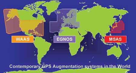
Satellite Based Augmentation System (SBAS) is one form of such augmentation system being developed as regional systems for large area coverages. Wide Area Augmentation System (WAAS) of USA, European Geostationary Navigation Overlay Systems (EGNOS) of Europe and MTSAT Satellite Augmentation System (MSAS) of Japan are the three emerging SBAS systems. These systems use navigation payloads on four geostationary INMARSAT third generation satellites and the core GPS.
Considering the important role that satellite based navigation systems will assume in the coming years, India has started preparations to implement and use a satellite navigation system. With rich experience in design and development of communications, meteorological, remote sensing and scientific satellites, India now intends to acquire hands on experience in satellite navigation in a phased manner that would culminate in the establishment of Indian Regional Navigational Satellite System (IRNSS).
Already,
Indian Space Research Organisation and Airports Authority of India are
implementing a SBAS over the Indian air-space for civil aviation, called
GAGAN (GPS And Geo Augmented Navigation). The space segment of GAGAN
will be in the form of an electronic device that works on two frequencies
and well matched with GPS system. It is planned to be flown on India’s
GSAT-4 in 2007. This will serve the Technology Demonstration System
Phase of the proposed navigational satellite system. The ground segment
consisting of eight Indian Reference Stations (INRESs), one Indian Master
Control Centre (INMCC), one Indian Land Uplink Station (INLUS) and associated
navigation software and communication links has been installed. Preliminary
System Acceptance Test has indicated that the position accuracies available
are good.
|
|

The Government has also approved in May 2006, a project to implement an Indian Regional Navigation Satellite System in the next six to seven years. It will consist of a constellation of seven satellites and a large ground segment. Three of the seven satellites in IRNSS constellation will be placed in Geostationary Earth Orbit and four in Geosynchronous Orbits inclined at 29° to the equatorial plane. All the seven satellites will have continuous radio visibility with Indian control stations.
The entire IRNSS system will be under Indian control. The space segment, ground segment and user receivers will be built in India. The independent, indigenously developed IRNSS is expected to provide an absolute position accuracy of better than 20 meter over India and the region extending to about 1,500 to 2,000 km around it. IRNSS system is expected to provide
•
Highly accurate position, velocity and time information in real time
for authorised users on a variety of vehicles
• Data with good accuracy for a single frequency user with the
help of Ionospheric corrections
• All weather operation on a 24 hour basis.
IRNSS satellites will weigh about 1,330 kg and their solar panels generate
1,400 Watt of power.
The
payload consists of state-of-the-art electronic equipment to generate
navigation signals and extremely accurate on-board atomic clocks. The
navigation signals will be in S-band
(2-4 GHz) and they are fed to a high performance phased array antenna
for the required coverage.
The ground segment of IRNSS constellation will include a Master Control Centre (MCC), ground stations that enable the accurate estimation of IRNSS satellite orbits besides ensuring the integrity of the network (IRIM), as well as ground stations that monitor the health of IRNSS satellites and capable of issuing necessary radio commands to them (TT&C stations).
IRNSS Satellite Locations |
MCC will estimate and predict the position of all IRNSS satellites, calculate integrity, makes necessary ionospheric and clock corrections and runs the navigation software. In this regard, the ground stations provide the necessary information and support to MCC for the smooth functioning of IRNSS network. In order to make the IRNSS truly independent, an Indian standard time infrastructure will be established.
|
A delegate interacting with one of the speakers |

Some of the technological challenges in establishing IRNSS include building, launching and maintaining the satellite constellation, adoption and maintenance of an Atomic Time Standard, establishment of Earth Stations, Master Control Stations, critical safety and verification subsystems, navigation software of international standard, user receiver manufacturing and time transfer technology.
With
the implementation of IRNSS, a key technologically challenging endeavour,
India
will take a major step towards providing an infrastructure for the provision
of Position, Navigation and Timing services throughout India and the
neighboring areas.
The Industry Meet held at ISAC, was important to expose the industry to the opportunities available in this programme and to find meaningful business opportunities in the Indian scenario. ISRO is also forging international partnerships with other core constellation providers and academic institutions. It is expected that major investment by the Government in IRNSS will generate an equivalent or more investment by the industry and entrepreneurs in the years to come and ISRO will consider funding critical technologies to enable the Indian industry to go hand in hand with ISRO.