Old River Control |
|
|
|
|
 |
Old River Control Symbol of Controversy |
|
To tell the story of Old River we have to change clocks. Our normal perspective, as we survey our world, is framed by our sense of the passage of time. Time for us passes far more quickly than it does for the Mississippi. The events that shape the Mississippi take place in geologic time. The geologic forces that shape the face of the earth are not well measured in days or even years. A century in geologic time is hardly the blink of an eye. To understand Old River we must begin by winding back the geologic clock through a few dozen millennia. Look at a map of the state of Louisiana and you can see it is shaped something like a boot. Over the course of many millennia the bottom half of that boot has been created by the Mississippi. Southern Louisiana is built entirely of river sediment carried by water from as far away as the Rocky Mountains. As the Jefferson River gushes down a Montana mountainside it picks up little bits of that mountain and carts them off to the Missouri River. As the Wabash flows through prime Indiana farm land it picks up some of that land and carries it to the Ohio River. The process is cumulative until finally, the Mississippi, loaded with two million tons per day of washed away mountain and farm field, reaches sea level and slows down enough to unburden its load in southern Louisiana. To build up all of southern Louisiana, the Mississippi has had to move around. Every couple of millennia it takes a major turn, abandons it's old channel, and finds a new one. The last time this happened was at the site where Donaldsonville now sits. Bayou Lafourche used to be the Mississippi. The next time this will happen will be at Old River.
When Henry was finished, the Red River flowed into the Atchafalaya and Old River, which used to be the bottom half of the loop, flowed out of the Mississippi and into the Atchafalaya. What Henry did was make it that much easier for the Mississippi to take the route of the Atchafalaya, and it would have too, except that the head of the Atchafalaya was blocked by the biggest stubbornest logjam anyone had ever seen. Well there it was, the situation was staring them right in the face, but the folks back then were thinking in human time. They wanted to navigate the Atchafalaya and so in 1863 the State of Louisiana took out the logjam. In the blink of a geologic eye (about one hundred years) the Atchafalaya widened and increased its draw on the Mississippi so that fully thirty percent of the Mississippi was pouring down the Atchafalaya. There is a fifteen foot difference now between the elevation of the two rivers and the Atchafalaya's route to the Gulf is approx. 140 miles shorter than the Mississippi's -- water always finds the shortest route downhill. By 1950 what was geologically inevitable became humanly apparent. The Mississippi River Commission delivered a report to Congress in 1953 that detailed the imminent capture of the Mississippi by the Atchafalaya. The result would be a human catastrophe and so Congress acted. They appropriated the funds and gave the U.S. Army Corps of Engineers the phenomenal job of stopping the geologic clock. Not only did Congress require that the Corps prevent the Mississippi from changing course at Old River, they also required that the Corps maintain the status quo. They couldn't simply block the Atchafalaya. The fresh Mississippi water that flowed into the Atchafalaya was necessary for the health of the Atchafalaya swamp. Morgan City at the mouth of the Atchafalaya needed that water as did the rural economy in the Atchafalaya basin. The Corps' job was to hold the Mississippi and yet maintain a constant flow of Mississippi water into the Atchafalaya. In effect they had to build a valve into the Mississippi that they could open and close as required. Easier said than done.
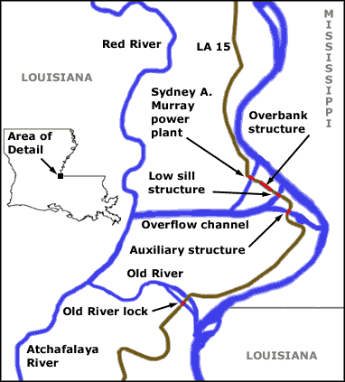
The map above shows conditions as they exist today. A lock on Old River makes it possible to travel between the two rivers. The overflow channel was dug when the original Low Sill structure was built in 1958. The Low Sill and Auxiliary structures work together to control the amount of water released into the Atchafalaya. The Overbank structure is a spillway that remains closed during normal and low water stages. It's gates are opened during high water to relieve stress on the Low Sill structure. The most recent addition to the complex is the Sydney A. Murray hydroelectric plant. Louisiana's first hydroelectric generator, it takes advantage of the fifteen foot head between the two rivers to generate power. Can they do it? Can the Corps keep the hands of the geologic clock from striking the final hour. The experts are all betting against them, but the experts are all focused on the geologic clock. What possible chance have we to deny nature. Are we going to cork a volcano, suture an earthquake fault, direct a hurricane or tell the Mississippi to please take the next right. Ask a Corps engineer and you're liable to get a wry smile and a, "who knows?" They're focused on the human clock. "We held it today and we'll hold it tomorrow." It's been thirty seven years they've held it now--thirty seven very human years--nearly half a lifetime. That's an achievement by any human measure and during that time we've benefitted from their efforts. Tomorrow I expect they will hold the Mississippi at Old River yet another day. Let the geologic clock tick if it must; I measure time by a different standard. If you'd like to learn more about the complex at Old River, you must read The Control of Nature by John McPhee. McPhee is a wonderful writer and The Control of Nature is one of the best books you'll ever read. It's so good that I suggest you turn off your computer right now and head straight for the library. This is one of those books you can't put down until you've read it straight through. |
 Calder would have understood Old River Control: the place where the work is attached to the ceiling, and below which everything -- New Orleans, Morgan City, the river swamp of the Atchafalaya -- dangles and swings.
 It's during floods that the river deposits sediment to build up the surrounding land. Sediment, carried by the river current, settles out as the water slows down. When sediment laden floodwater breaches the river bank it slows down and the heaviest sediment is deposited nearest the bank. Likewise when the river reaches sea level it slows and sediment is deposited in the channel. Together these actions work over the course of centuries to raise the river up above the surrounding countryside. Southern Louisiana, as we noted, is composed entirely of river silt which slowly subsides under its own weight. The land farthest away from the river doesn't receive enough flood sediment to offset this subsidence and it sinks. Over the course of geologic time the river rises up on its own sediment as the surrounding land sinks under its own weight. This process eventually produces a difference in elevation between the two that gravity will not tolerate. One day (in human time), during high water, the river finds a weakness in it's natural levee and within hours a new river channel emerges.
 When Pierre d'Iberville sailed into the mouth of the Mississippi in 1699 he wasn't thinking in geologic time. Neither was his brother Jean de Bienville when he founded New Orleans in 1718. By then the Mississippi was already leaking into the Atchafalaya. At the location we now call Old River, about 314 miles from the river's mouth, there was a loop in the river not unlike the New Madrid loop today. Three rivers met in that loop. The Red River from Texas flowed into the Mississippi while the Atchafalaya River flowed out. When New Orleans was a bustling and prosperous city just a few years beyond one hundred, Henry Shreve was a Mississippi river hero. In 1831 steamboats by the hundreds plied the river's treacherous waters. Captain Shreve had already distinguished himself by inventing the snag boat. Snag boats travelled up and down the Mississippi removing sawyers from the river. (A sawyer was a submerged tree that could snag and even sink a steamboat). Henry Shreve also wasn't thinking in geologic time when he decided to dredge across the neck of that river loop at mile 314. He cut off the loop and shortened the river channel and at the same time created Old River.

 It's been nearly forty years since the Low Sill and Overbank structures went into operation in 1963. But what is forty years in geologic time--not even the blink of an eye. Since then there have been a number of skirmishes in the battle engaged. In 1973 the Corps almost lost. The 1973 flood nearly destroyed the Low Sill structure. It's been repaired but it's no longer up to its original design specifications. The river claimed the southern wing wall of the structure, and nearly undermined its foundation which is sunk ninety feet into the river bottom. Originally designed to withstand a difference of thirty seven feet in water levels between a raging Mississippi and a hungry Atchafalaya, the Low Sill structure has been repaired to withstand a head difference now of twenty two feet. To bolster its efforts the Corps have constructed the Auxiliary structure which went on line in 1986. Between the two they are now better prepared than before, to hold the Mississippi in place.