Barlow Road
|
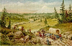
In 1845, 53 year old Samuel K. Barlow of Illinois
arrived at The Dalles. He became very disgruntled at the high tolls
being charged to transport emigrants down the Columbia. He was also
very concerned about the extreme hazards of the trip. Barlow scouted
out a wagon road around the south side of Mt. Hood, which he began
operating as a toll road in 1846. It was a very rough road, with
trees and rocks making the journey even more difficult.
The Barlow Road was the last overland segment
of the Oregon Trail before reaching the Willamette Valley. This
road provided an alternative to the dangerous and expensive route
that used rafts to transport wagons down the Columbia River. But
it was not free. The Barlow Road was the first place on the 2,100
mile Oregon Trail where tolls were charged. When the road opened
in 1846, tolls were $5.00 per wagon and 10 cents for every head
of livestock. Five dollars was about one week's wages, but consider
the alternative -- floating down the Columbia River in boats or
rafts cost nearly $50.00! By 1863, tolls had changed to $2.50 per
wagon and team, 75 cents for horse and rider, and 10 cents for other
livestock.
The Barlow Road operated under many owners as a toll road from 1846
to 1919. There were no tolls after 1919 when the estate of the final
owner deeded the road to the State of Oregon.
Where was the Barlow Road located?
Many say the Barlow Road started in The Dalles,
but in 1845 when Sam Barlow scouted the new road, a route already
existed from The Dalles to Tygh Valley. By 1850, many emigrants
by-passed The Dalles. They went straight from the John Day River
to Tygh Valley, crossing the Deschutes River at Sherar's Bridge.
Tygh Valley could be considered the beginning of the Barlow Road.
The National Park Service considers the start of the road to be
the first tollgate site at Gate Creek. Whatever starting point you
choose, the ending was always Oregon City--the "End of the Oregon
Trail."
The Barlow Road Today
The Oregon Trail was named a National Historic
Trail by Congress in 1978. The Historic Trail designation was meant
to protect the trail remnants and artifacts for public enjoyment.
Very little of the original Oregon Trail is visible today, about
20 percent. Of this 20 percent, approximately 10 percent is on National
Forest land. On April 13, 1992, the Barlow Road was placed on the
National Register of Historic Places as a Historic District.
The Mount Hood National Forest maintains 40 miles of Barlow Road
corridor. Much of the road on the Forest is still in use today for
recreation activities. About 30 miles remain "intact," but not always
in a form you would expect. The Barlow Road underwent an evolution
of travel modes--from oxen-pulled wagon to Model A Fords. In the
Zigzag Valley, much of the original route is beneath U.S. Highway
26. Motorized travel meant mechanized re-routing and maintenance.
The new motorized routes (including Mount Hood Loop Highway of 1924)
left many isolated pieces of "pristine wagon ruts." Rut traces are
still visible today.
The ruts are actually a swale--a five to six foot wide trench worn
out by the wagon and the stock that pulled them. Near "Pioneer Woman's
Grave," they get four to five feet deep. Fine traces exist within
200 feet of paved parking at Pioneer Woman's Grave and Barlow Pass.
The one mile hiking trail from Barlow Pass to Pioneer Woman's Grave
has some of the best rut traces to be seen; they are marked with
rustic "Original Wagon Route" signs. There are also fine traces
near Devil's Half Acre. Without formal maps, ruts on Laurel Hill
are for the true "rut nuts" to search out. Wagons were lowered at
Laurel Hill; a stump with rope burn was near the top of chute number
two, but the marks have disintegrated through time.
Pioneer graves can still be seen. In addition to "Pioneer Woman's
Grave," several others exist at Summit Meadow. These are on private
land across the street from where the Summit House stood.
Previous Location | Next
Location
Northwest Landmarks List
|
|
|
|
Page Navigation
Top of page
History Menu Bar
Education Menu Bar
Main Menu Bar
Privacy
& Disclaimer
Webmaster: Renee Rusler
Last modified on:
May 25, 2004
|