
Kilinailau (Tulun) Islands
- Landsat 7
- Path 91 Row 63
- 16 June 2000
The northeastern edge of both PNG and Solomon Islands territory is marked by a line ofmedium-sized atolls and reefs that extend from southeast to northwest for some 900 km, running parallel to the islands of the Solomon and Bismark groups. The chain includes such features as the atolls of Ontong Java, Roncador Reef and Nukumanu (belonging to the Solomon Islands), and the PNG possessions of Taku'u, Kilinailau, the Nuguria Islands and the submerged Lyra Reef.
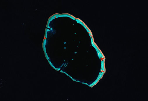
The Kilinailau Islands (also known as the Tulun Islands or Carteret Atoll) are located 86 km northeast from the northern end of Bougainville Island; the Taku'u atoll lies 166 km directly to the east and the Nuguria Islands 147 km to the northwest.
The atoll has a diameter of 24 km and contains 6 low coral islands (including Han, Iagain, Iesala, Iolasa, and Piul) with a combined land area of around 0.6 km². Strucurally, the atoll consists of a near continous outer reef with a wide and pronounced algal ridge on the eastern side; the thinner rim of the west lies in slightly deeper water and is broken by two major passages that lead in to the deep central lagoon. Several large reef structures with small islands are located within the centre of the lagoon.
Synonyms: Carteret Atoll, Carteret Islands, Tulun Islands
image: millenium coral reefs landsat archive/usf millenium global coral reef mapping project/nasa seawifs/nasa jsc
Location Map
