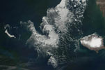
St Matthew Island
- Terra MODIS
- 04 June 2001
- 22:57 UTC
St Matthew Island is located in the central regions of the northern Bering Sea, 265 km west from Nunivak (see panoramic image) and 306 km south from Saint Lawrence Island. It is the largest island of the St Matthew Island Group: the small Hall Island lies 5 km across the Saricheff Strait from St Matthew's northwestern tip; the tiny Pinnacle Island and its minor islets (just visible in the above image) are situated 13 km off the southern coast.
St Matthew Island is narrow and elongate in form, measuring 53 km in length with widths of between 1 and 6 km, covering an area of 357 km². The subartic tundra of the interior contains a rolling landscape of low hills separated by broad river valleys, rising to a height of 421 m above sea level at Sugarloaf Mountain on the southern coast. The coastline comprises a mix of steep slopes, cliff and beaches with coastal lagoons present on both the northern and southern coasts of the eastern side of the island.
image: MODIS rapid response project at nasa/goddard space flight center