USDA Forest Service
 

Mount St. Helens National Volcanic Monument


Gifford Pinchot
National Forest

Forest Headquarters
10600 N.E. 51st Circle
Vancouver, WA 98682
(360) 891-5000
TTY: (360) 891-5003

Cowlitz Valley
Ranger District

10024 US Hwy 12
PO Box 670
Randle, WA 98377
(360) 497-1100
TTY: (360) 497-1101

Mt. Adams
Ranger District

2455 Hwy 141
Trout Lake, WA 98650
(509) 395-3400
TTY: (360) 891-5003


Mount St. Helens
National Volcanic
Monument

Monument Headquarters
42218 N.E. Yale Bridge Rd.
Amboy, WA 98601
(360) 449-7800
TTY: (360) 891-5003

Coldwater Ridge Visitor Center
3029 Spirit Lake Highway
Castle Rock, WA 98611
(360) 274-2114

Johnston Ridge Observatory
3029 Spirit Lake Highway
Castle Rock, WA 98611
(360) 274-2140

Mount St. Helens
Visitor Center

3029 Spirit Lake Highway
Castle Rock, WA 98611
(360) 274-0962
(Operated by Washington State Parks and Recreation Commission)


Hiking Trails

Explore New Landscapes

There are many trails in the Mount St. Helens National Volcanic Monument leading hikers into a variety of diverse landscapes.

Crater views, new lakes, ancient lava flows, blown down trees, mudflows and old-growth forest can all be discovered here.

Trails vary in difficulty from short, accessible interpretive loops to longer, steep narrow trails that challenge even experienced hikers. Consult with Monument staff to pick the trails that best meet your needs.

To ensure your safety, wear sturdy shoes and familiarize yourself with the Ten Essentials. All hikers are responsible for their own safety.

Winds of Change Interpretive Trail


Trails in the Restricted Area

A restricted area has been established in the heart of the National Volcanic Monument to protect opportunities for scientific research and allow for the recovery of plant and animal life. The following rules apply in the restricted area:
  • Stay on the trail; off-trail travel prohibited. ($100.00 minimum fine).
  • No camping is allowed in the restricted area.
  • Disturbing research plots or removal of any natural feature is strictly prohibited.
  • Access into the crater is strictly prohibited.
  • Fires are not allowed within the blast area. Stoves are allowed within the blast area.
  • Pets and bicycles are prohibited.
For more detailed information and maps, contact one of the Visitor Centers or a Forest Ranger District Office.
Independance Pass


Be Prepared - Bring The Ten Essentials
  1. Map and knowledge of the trail you're hiking. Let someone know your destination and your return time

  2. Flashlight

  3. Extra food

  4. Extra Clothing

  5. Sunglasses/ sunscreen/ hat for blast area

  6. First aid kit

  7. Pocket knife

  8. Waterproof matches, candles or fire starter

  9. Water or the means to purify water (some areas are hot and dry in the summer)

  10. Tarp, tent or emergency shelter
St. Helens Lake


Symbols Key

Users
Hiking Hiking
Barrier Free Trail Accessible
Horse Riding Horseback
Mountain Bike Riding Mountain Bike
Caving Caving
Trail Difficulty Definitions
Easiest Easiest: Level to gently rolling. Easy hiking, suitable for children or individuals seeking a leisurely walk.
More Difficult More Difficult: Vigorous hiking with moderate hills and slopes.
Most Difficult Most Difficult: Steep grades, narrow tread widths, low levels of maintenance. May require stepping over logs or traversing steep slopes or stream fords. Trails may be difficult to locate or follow. Suitable for experienced hikers in good physical condition. Expect a challenging experience.
Trailhead Facilities
Picnic Area Picnic Area
Parking Parking
Camping Campground
Restrooms Restrooms
Drinking Water Drinking Water
Information Station Information Station
Northwest Forest Pass Required at Trailhead Northwest Forest Pass Required at Trailhead


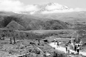
West Side Trails

West side trails offer close-up views of the crater, newly formed lakes and the barren pumice plain. Hike on the landslide deposit and discover how water has created new habitats.

Drinking water is located at Coldwater Lake and the Visitor Centers.
Trail Number & Name Uses Difficulty Length
(miles)
Dogs Allowed? Trailhead Facilities Elevation Change
246 - Birth of a Lake* HikingBarrier Free Trail Easiest 0.25 No ParkingRestroomsDrinking WaterPicnic Area None
1 - Boundary
   (Legs 1-6)
Hiking All
Difficulties.
19
30.1 Total
No Northwest Forest Pass Required at Trailhead up to 3000 ft.
211D - Elk Bench Hiking More Difficult .75 No Parking 600 ft.
Eruption* HikingBarrier Free Trail More Difficult .50 No ParkingRestrooms 100 ft.
229 - Hummocks Hiking More Difficult 2.4 No ParkingRestroomsDrinking Water 300 ft.
211 - Lakes Hiking Most Difficult 13.2  No ParkingRestrooms 2700 ft.
Silver Lake Wetlands* HikingBarrier Free Trail Easiest 1.0 No ParkingDrinking Water None
230A - South Coldwater Hiking More Difficult 3.14 No Parking 1300 ft.
232 - Winds of Change* HikingBarrier Free Trail Easiest 0.25 No ParkingRestroomsDrinking WaterPicnic Area None
* Interpretive Trails


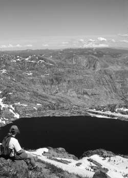
East Side Trails

East, beyond the reach of the volcano's power, old-growth forests and lush vegetation offer a sharp contrast to the gray in the blast area. Trails along Forest Road 99 lead hikers into the heart of the blast area and provide outstanding views of Spitit Lake.

Water pumps are located at Norway Pass Trailhead on Forest Road 26 and the Meta Lake Trailhead on Forest Road 99.
Trail Number & Name Uses Difficulty Legth
(miles)
Dogs Allowed? Trailhead Facilities Elevation Change
1 - Boundary Norway Pass Trailhead to Norway Pass Hiking Most Difficult 2.5 No ParkingRestroomsDrinking Water 840 ft.
224 - Harmony Hiking More Difficult 1.0 No ParkingNorthwest Forest Pass Required at Trailhead 572 ft.
227 - Independance Pass Hiking More Difficult 3.4 Yes ParkingNorthwest Forest Pass Required at Trailhead 500 ft.
187 - Iron Creek CG Hiking Easiest 1.5 Yes ParkingRestroomsDrinking WaterCamping None
83 - Iron Creek Old-Growth HikingBarrier Free Trail Easiest 0.25 Yes ParkingRestroomsDrinking WaterPicnic Area None
210 - Meta Lake* HikingBarrier Free Trail Easiest 0.2 Yes ParkingDrinking WaterNorthwest Forest Pass Required at Trailhead None
207 - Truman Hiking More Difficult 6.2 No ParkingRestroomsNorthwest Forest Pass Required at Trailhead 1200 ft.
247 - Woods Creek Watchable Wildlife HikingBarrier Free Trail Easiest 2.5 Yes ParkingRestroomsPicnic AreaNorthwest Forest Pass Required at Trailhead None
* Interpretive Trails


South Side Trails

South side trails offer outstanding opportunities to learn about ancient lava flows and recent mudflows that scoured down the slopes of Mount St. Helens. Discover the longest continuous lava tube in the continental U.S. formed more than 1,900 years ago.

There are no water pumps on this side of the Monument.
Trail Number & Name Uses Difficulty Length
(miles)
Dogs Allowed? Trailhead
Facilities
Elevation
Change
239A - Ape Cave (Lower Spur) HikingCaving More Difficult 0.75 No ParkingRestrooms 100 ft.
239B / 239 - Ape Cave (Upper)
Return on Surface Trail
HikingCaving Most Difficult 1.5 No ParkingRestrooms 400 ft.
234 - Ape Canyon HikingMountain Bike Riding More Difficult 4.6 Yes ParkingNorthwest Forest Pass Required at Trailhead 1400 ft.
216B - June Lake HikingMountain Bike Riding More Difficult 1.6 Yes ParkingNorthwest Forest Pass Required at Trailhead 500 ft.
184 - Lava Canyon* HikingBarrier Free Trail All Difficulties. 1.7 Yes ParkingRestroomsPicnic AreaNorthwest Forest Pass Required at Trailhead 1350 ft.
216 - Loowit
(Round the Mountain)
HikingMountain Bike Riding
Bikes not
allowed
in Blast Zone
All Difficulties. 27 No   Varied
240 - Sheep Canyon HikingMountain Bike RidingHorse Riding More Difficult 2.1 Yes ParkingNorthwest Forest Pass Required at Trailhead 1200 ft.
233 - Trail of Two Forests* HikingBarrier Free Trail Easiest 0.3 Yes ParkingRestroomsPicnic AreaNorthwest Forest Pass Required at Trailhead None.
* Interpretive Trails

USDA Forest Service
Gifford Pinchot National Forest - Vancouver, WA
Mount St. Helens National Volcanic Monument - Amboy, WA
Last Modified: Monday, 27 September 2004 at 16:10:04 EDT


USDA logo which links to the department's national site. Forest Service logo which links to the agency's national site.