Asarco Site Tour Asarco Site Tour
See how CPRD worked with the U.S. Environmental Protection Agency (EPA), state environmental agencies, and responsible parties to help create a new habitat as part of a hazardous waste site clean-up. The following photographs were taken on August 28, 2000 during a site visit sponsored by Asarco to view the removal of slag from the intertidal zone, the protection of remaining slag from erosion, and construction of new intertidal habitats.
(11 images)
|
|
 AVP: Aunuu Debris Field, American Samoa AVP: Aunuu Debris Field, American Samoa
Debris field from a grounded vessel on the west shore of Aunuu Island, American Samoa. Debris is close to homes and accessible to the local children. Pieces are also on the reef flat and are likely moved in storms.
(17 images)
|
|
 AVP: Debris Field from #62 Nam Sung, Rota, CNMI AVP: Debris Field from #62 Nam Sung, Rota, CNMI
Large debris field that resulted from the grounding of a large fishing vessel on the island of Rota in CNMI. There are large pieces of debris scattered from the beach across the reef flat.
(8 images)
|
|
|
 Big Elk Creek GPS Location 25 Big Elk Creek GPS Location 25
Although Big Elk Creek is not strictly in the study area for the project, observations were made to allow comparison with conditions in Little Elk Creek. At location 25, Big Elk Creek passes next to a City Park and the riparian vegetation is primarily lawn. One team member reported having previously visited this location and watched shad milling around below the bridge, taking turns fighting the current on their way upstream.
(2 images)
|
|
 Deepwater Horizon Response Deepwater Horizon Response
Images from OR&R;'s participation in the response to the Deepwater Horizon oil spill in the Gulf of Mexico.
(5 images)
|
|
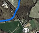
 Dogwood Run GPS Location 12 Dogwood Run GPS Location 12
Location 12 is where Dogwood Run crosses under SR 545 (also known as Blue Ball Road). The team walked under the downstream side of the bridge and noted that concrete had been poured across Dogwood Run to protect several small pipes and conduits. It appeared that several of the pipes were no longer serviceable; it was unclear whether there were viable utilities buried deeper in the concrete. The streambed below the utility crossing was down-cut approximately one foot, creating a fish passage barrier. The water flowing over the crossing was only a few inches deep. There were large burlap bag-shaped concrete structures lining the left bank under the box culvert; these were apparently intended to protect the bridge abutment. On the right bank, there were a few bags but several bags appeared to have washed out and were scattered in the streambed below the road crossing. The riparian zone on the right bank is narrow, 6 to 9 m (20 to 30 feet), and is directly adjacent to the downstream edge of the Triumph Industrial Park. The Triumph Industrial Park has mowed grass in the area closest to Dogwood Run.
(5 images)
|
|
 Dogwood Run GPS Location 36 Dogwood Run GPS Location 36
Location 36 is where Dogwood Run crosses under SR 213 in a culvert. The creek is narrow at this location and quite overgrown with shrubs. The culvert has an open bottom that does not restrict flow. The substrate is sand and gravel.
(7 images)
|
|
Dogwood Run GPS Location 37
Location 37 is where Maple Springs Farm Road, a single lane road, crosses Dogwood Run. The creek is routed through two 36- to 42-inch corrugated culverts under the road. At the time of the visit, all of the flow was through the central culvert, which is slightly lower than the western culvert. The eastern culvert was high and dry and bent out of shape. The bottom of the central culvert was apparently rusted through and there was sand and gravel under the bridge. The culverts would not restrict fish passage, although the flow was only a few inches deep, which probably precludes use by most fish. There was a rack of sticks and branches lodged against the entrance to the culvert. The riparian zone on both banks for a few hundred yards upstream and downstream of the road crossing is mowed grasses. Beyond the developed areas, the condition of the riparian zone improves. The creek substrate is predominately sandy and there was abundant algae, probably indicating the presence of elevated levels of nutrients in the water.
(5 images)
|
|
 Dogwood Run GPS Location 38 Dogwood Run GPS Location 38
Location 38 is where Carriage Road crosses Dogwood Run. At this location, the creek approaches the road at an angle of about 30 degrees and passes through twin 48-inch culverts embedded in a concrete headwall. Because the flow was so low during the visit, all of the flow passed through the eastern culvert. There was no barrier to fish migration other than insufficient flow. There is riprap in the pool downstream of the road and as with location 37, there was evidence of eutrophication in the stream bed. An iron-stained seep was entering the creek on the left bank a few feet downstream of the road. Upstream, the riparian zone consists of mowed grasses and widely spaced deciduous trees that appear to be part of a landscaping effort for the property. There was some wetland emergent vegetation on the left upstream bank several feet above the creek. Downstream the banks were mowed but the riparian zone transitions into forest cover within 30 m (100 feet). The right bank downstream of the road is vertical and bare, indicating possible down-cutting during high flow events.
(8 images)
|
|
 Dogwood Run GPS Locations 13 to 19 Dogwood Run GPS Locations 13 to 19
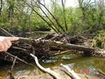
Location 16 is at the confluence of Dogwood Run and Little Elk Creek, where the field team observed a beaver dam and two beavers returning to their hutch. The dam disrupted the flow but did not appear to create a complete blockage � the water on the upstream side of the dam was not pooled. There is evidence of channel migration processes at this location; there is an abandoned oxbow channel of Little Elk Creek on the left bank. There are also ATV tracks in the area, indicating that recreational users have access to this area with equipment that is likely to be disruptive to fish and wildlife. The riparian zone of Little Elk Creek at this location is healthy and wide, with trees and shrubs. The stream bed is gravel with some cobbles. Dogwood Run has a gravelly, cobbley bed and the flow was probably too low to be passable by fish.
(7 images)
|
|
|
 Dogwood Run GPS Locations 39 and 40 Dogwood Run GPS Locations 39 and 40
Locations 39 and 40 are where Dogwood Road crosses Dogwood Run at a bridge. At this location, there is good riparian cover on the left bank downstream and a residential property on the right bank. On the upstream side there are residential properties on both banks for 30 m (100 feet) or so and then the riparian zone transitions to forest cover. English ivy was noted on the right upstream bank. Dogwood Run was approximately 4.5 m (15 feet) wide and straight in this reach. A riffle was visible in the distance upstream and there were cobbles in a bar downstream, less than one foot above the active low-flow channel. The road crosses Dogwood Run in a single span bridge that does not impede fish passage. There was algae in the creek and more trash in the creek than in most areas the team had visited in the watershed.
(6 images)
|
|
 Dune Vehicle Boneyard Dune Vehicle Boneyard
A debris waste site on one of the Pribilof Islands in Alaska's Bering Sea.
(14 images)
|
|
 Elk River GPS Location 27 Elk River GPS Location 27
At location 27, Elk River is murky with a distinctively tidal appearance, and is approximately 30 m (100 feet) wide. The vegetation is dominated by phragmites on the left bank and lawn on the near bank. There are no riparian shrubs or trees at location 27 but there are trees in patches, particularly in the upstream direction. There is a dock at location 27, and other docks were visible in the upstream and downstream directions.
(3 images)
|
|
 Exxon Valdez Oil Spill Exxon Valdez Oil Spill
Photos taken after the tanker Exxon Valdez grounded on Bligh Reef in the upper part of Prince William Sound on March 24, 1989. The tanker was carrying approximately 53 million gallons of crude oil. Within a few days, it had spilled almost 11 million gallons of the oil into Prince William Sound.
(22 images)
|
|
 Gravelly Run GPS Locations 21 and 22 Gravelly Run GPS Locations 21 and 22
Locations 21 and 22 are at the confluence of Little Elk Creek and Gravelly Run. Residents who happened by stated that Little Elk Creek frequently floods and overtops that road and bridge. From the bridge, one can see crops planted right up to the banks of Little Elk Creek in the downstream direction on both banks and on the right bank in the upstream direction. The left upstream bank had a healthy, wide riparian zone. Gravelly Run has sandy, gravel substrate and is on the order of 4.5m (15 feet) wide and 15 cm (6 inches) deep. There is also a high water side channel of Little Elk Creek, which was consistent with the accounts of high water told by the residents.
(10 images)
|
|
 Gravelly Run GPS Locations 23 and 24 Gravelly Run GPS Locations 23 and 24
Locations 23 and 24 are upstream on Gravelly Run where it crosses under SR 545 in a box culvert. There is a benchmark, elevation 18.6 m (61 feet), at the location. Gravelly Run is about 4.5 m (15 feet) wide and 15 to 30 cm (6 to 12 inches) deep at that location. The box culvert is not an impediment to upstream fish migration but the shallow water depth may be.
(5 images)
|
|
|
|
 Laurel Run GPS Location 20 Laurel Run GPS Location 20
Location 20 is where Zeitler Road passes through Elkton Farm. At the west end of the farm, Zietler Road crosses Laurel Run, a tributary to Little Elk Creek. At this location, there is a partially washed out bridge, which has been replaced with a concrete ford that is used for vehicle traffic. The stream bed below the ford is downcut as much as 2 m (6 feet), causing a clear blockage to upstream fish passage (photo). The water was clear and the creek bed was cobbly. The riparian vegetation was healthy and wide.
(6 images)
|
|
 Little Elk Creek GPS Location 26 Little Elk Creek GPS Location 26
Location 26 is where Little Elk Creek crosses under a large bridge for US 40. There were no flow obstructions at this location and except for erosion protection associated with the bridge abutment, the creek appeared to be in good condition. The creek was 9 to 15 m (30 to 50 feet) wide and 0.3 to 1 m (1 to 3 feet) deep. The span of the bridge is quite wide, leaving plenty of room for high flow channels on the east side of the main channel. The riparian zone upstream and downstream of the bridge was wide and healthy.
(7 images)
|
|
 Little Elk Creek GPS Location 34 Little Elk Creek GPS Location 34
Location 34 is where Interstate 95 crosses over Little Elk Creek, just downstream of the SR 545 crossing. The bank is heavily protected with riprap under the crossing and the substrate seems to contain many pieces of riprap that presumably washed out of the bank protection structures in the past. Approximately 30 m (100 feet) downstream of the I-95 bridge, trees and shrubs are present in the riparian zone, and substrate in the creek transitions to natural materials. There are trees on both creek banks although the riparian zone on the right bank is narrow and agricultural fields were visible through the trees. There are cobbles in a bar on the right bank between SR 545 and I-9, and the riparian zone vegetation appears to be well developed further upstream.
(3 images)
|
|
 Little Elk Creek GPS Location 35 Little Elk Creek GPS Location 35
(Approx. 2 miles north of the area shown on the top map.) Location 35 is at the Spectron Superfund Location where Providence Road crosses Little Elk Creek. Historical groundwater contamination from the Spectorn/Galaxy site had leached into Little Elk Creek, prompting regulatory agencies into action. In addition to pump-and-treat to control the groundwater plume, the remedy included installation of a plastic liner in the creek bed to stop discharge of contaminated groundwater into the creek. At the time of the visit, the creek appeared to be in good condition and was approximately 8 m (25 feet) wide. A dam with a 2.5 to 3 m (8 to 10 foot) drop is located just upstream of the stopping point. According to information available at the time, another flow obstruction was located just downstream of Providence Road, but a by-pass has been constructed around the east side of that blockage.
(8 images)
|
|
 Little Elk Creek GPS Location 50 Little Elk Creek GPS Location 50
Location 50 is a site with historical buildings on the left bank of Little Elk Creek, approximately 150 m (1/10 of a mile) upstream from the confluence of Little and Big Elk Creeks. The creek was at least 30 m (100 feet) wide and appeared to be tidally influenced. The left bank slopes gently to the water and is fairly muddy; the right bank is near vertical and about 0.6 m (2 feet) tall. The substrate is fine-grained. Phragmites dominated the right bank and mowed lawn dominated the left bank. Trees form a riparian buffer further downstream where Big Elk Creek comes in from the left.
(4 images)
|
|
 Little Elk Creek GPS Locations 1 to 11 Little Elk Creek GPS Locations 1 to 11
Little Elk Creek is quite impressive in this reach, in spite of the proximity to the Triumph Industrial Park. The creek is approximately 20 m wide (60 feet). Tall deciduous trees and shrubs are present on both banks and effectively shield buildings and paved areas from view. During the walk between locations 1 and 11 the team noted gravel bars in Little Elk Creek, a series of meanders with cut banks and point bars, and a healthy band of trees and shrubs on both sides of the creek. The cut banks vary in height from 1.2 to 2.5 m (4 to 8 feet). The creek has a series of pools and riffles with water depths in the 0.3 to 1 m (1 to 3 foot) range. In this reach of the creek, the bed materials are predominantly gravel and cobbles. Further upstream, there is a section of the bed with exposed bedrock. Several trees had fallen into the creek from the banks, adding complexity to the system. Some of the downed trees appeared to be quite fresh with healthy leaves; a recent significant storm may have caused the bank undercutting that felled the trees. The team later heard from residents that there had been a significant storm within the last month or so, which may have caused bank undercutting that felled the trees.
(11 images)
|
|
 Little Elk Creek GPS Locations 1 to 11 - Part 2 Little Elk Creek GPS Locations 1 to 11 - Part 2
There was very little anthropogenic debris in this stretch of Little Elk Creek and the adjacent riparian zone. The team crossed a drainage ditch entering the creek from the north, which had a low flow of heavily iron-stained water. The ditch came from the Triumph Industrial Park, but the field team could not track the ditch back to its source. Further upstream, the team observed a rock wall on the right bank (all references to right and left bank are based on looking downstream). The wall is constructed out of quarried rock stacked 1.2 to 1.5 m (4 to 5 feet) high (photo). There is a concrete thrust block on the downstream end, which had a dirt-filled pipe sticking out toward the creek. Several of the quarry rocks on the upstream side are displaced and falling into the creek. This rock wall could be replaced with bioengineered bank protection but it represents a small fraction of the reach of Little Elk Creek as observed from this location.
(12 images)
|
|
 Little Elk Creek GPS Locations 28 to 30 Little Elk Creek GPS Locations 28 to 30
Location 30 is where Little Elk Creek crosses under the Old Field Road bridge. The bridge is supported by one mid-span pier with a sand bar on the downstream side and large woody debris on the upstream side. There were houses on the left bank both upstream and downstream, which had large lawns extending all the way to the creek's edge. The creek was approximately 30 m (100 feet) wide with a cut bank on the right bank and a gently sloping left bank. The diversity of the riparian vegetation improved both upstream and downstream of the residences.
(8 images)
|
|
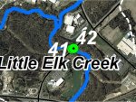 Little Elk Creek GPS Locations 41 and 42 Little Elk Creek GPS Locations 41 and 42
Locations 41 and 42 are where Little Elk Creek passes under State Route 279 at a wide bridge. The riparian zone was mowed grasses for 30 m (100 feet) or so up and downstream of the bridge and forest beyond that distance. In the downstream direction, there is a cobble bar on the right bank and tree branches hanging over the creek, providing shade. There is also a linear feature oriented perpendicular to the stream channel, constructed of 8 to 12 inch angular rock, the purpose of which may be to protect a buried utility. Upstream, the left bank is gently sloped with cobbles in the bank and large woody debris in and adjacent to the creek. The upstream right bank is about 1 m (3 feet) tall and well vegetated. A high-flow channel re-enters the main channel just upstream of the bridge. The substrate of the active channel is predominantly sand.
(10 images)
|
|
 Major Oil Spills Major Oil Spills
A gallery featuring photos of some of the world's largest oil spills, along with a little information about each of those spills.
(10 images)
|
|
|
|
|
|
 Mearns Rock Time Series Mearns Rock Time Series
A photo time series of Mearns Rock, a large boulder located in the intertidal zone at Snug Harbor on Knight Island, Prince William Sound, Alaska.
(20 images)
|
|
 Mill Creek GPS Location 31 Mill Creek GPS Location 31
Location 31 is where a small private road crosses the south tributary of Mill Creek into Mill Creek Estates. There is a single-lane wooden bridge crossing the creek and lawn in the developed area. Further upstream, the tree coverage increase in the riparian zone. The south tributary of Mill creek is approximately 3 to 4.5 m (10 to 15 feet) wide, the channel banks are nearly vertical on the left bank and gently sloping on the right bank. The substrate is gravel.
(3 images)
|
|
 Mill Creek GPS Location 47 Mill Creek GPS Location 47
Location 47 is where an unpaved track leading to the Maryland Sand Gravel and Stone Superfund site, crosses over the south tributary of Mill Creek. The creek water is stained a bright orange color at this location and phragmites are abundant in and adjacent to the creek. The creek is only 1 to 2 m (3 to 5 feet) wide and a few inches deep, without discernable banks. This area may be poor fish habitat due to degraded water quality, lack of suitable habitat, and insufficient flow.
(4 images)
|
|
 Mill Creek GPS Locations 32 and 33 Mill Creek GPS Locations 32 and 33
Locations 32 and 33 are where the north tributary of Mill Creek approaches the confluence with the south tributary. The team walked from a small road toward Old Elk Neck Road and examined the main stem of Mill Creek on both sides of the culvert passing under the Old Elk Neck Road. There is an extensive riparian zone on the lower reaches of Mill Creek and on both tributaries when looking upstream. There was some trash and debris in the riparian zone, which was uncharacteristic of other areas in the watershed. The creek is on the order of 4.5 to 6 m (15 to 20 feet) wide downstream of the bridge and has gently sloping banks on both sides. The creek flows under the road in three short spans. There is no flow restriction. The substrate here is finer (sand) than at upstream locations.
(5 images)
|
|
 Mill Creek GPS Locations 43 and 44 Mill Creek GPS Locations 43 and 44
Locations 43 and 44 are where the north tributary of Mill Creek passes under Route 7. The land on the south side of Route 7 is manicured and passes through a road maintenance facility in a ditch, with young phragmites beginning to grow on the bank. The water course was approximately 0.5 to 1 m (2 to 3 feet) wide and a few inches deep at the time of the visit. The fish habitat value is very poor. The channel upstream of Route 7 is in much better condition, with sand and gravel in the bed and trees overhanging the banks. The depth of the water was only a few inches and provided little to no fish habitat value, especially considering the downstream condition of the creek. The creek flows through twin 40-inch diameter corrugated steel pipes under the road, although only one pipe carried flow during our visit.
(4 images)
|
|
 Mill Creek GPS Locations 45 and 46 Mill Creek GPS Locations 45 and 46
Locations 45 and 46 are where the south tributary of Mill Creek crosses under Route 7. Mill Creek varies between 2 and 4.5 m (10 and 15 feet) in width at this location. Upstream of the road, the substrate is sand with some angular cobbles. There are trees and shrubs overhanging the water course and there was no indication of erosion on the shallow banks. Downstream of the road, the channel bed is sand and small gravel with some large angular rocks up to 24 inches across. The water had an orange, iron-stained tint. The creek passes under the road through three semicircular arches that do not obstruct fish passage. The owner of a nearby property reported that there were no anadromous fish in this reach of Mill Creek. However, he reported having observed small resident fish of several different species including sun fish, chain pickerel, "small brown fish", and what he described as lamprey eels. In his opinion, beaver dams, further downstream on the creek, were an impediment to fish migration.
(5 images)
|
|
 Mill Creek GPS Locations 48 and 49 Mill Creek GPS Locations 48 and 49
Locations 48 and 49 are where US 40 crosses over the south tributary of Mill Creek. The creek is relatively straight and slow-moving upstream of the highway, and passes under the road through a rectangular culvert. Water in the creek was iron-stained and algae was observed. The creek passes through a forested area that provides a full riparian buffer. The creek bed is sand and gravel. Downstream of the highway, the apron of the culvert drops approximately one foot to a pool. This drop could be a fish passage obstruction, although beaver dams downstream (as described at locations 45 and 46) may preclude migratory fish from this location. A downed tree straddled the creek a few feet downstream of the culvert apron. The creek banks are 0.5 to 1 m (2 to 3 feet) high below the highway, which may indicate downcutting. The riparian vegetation is a good mix of trees and shrubs. There was evidence of repairs to the highway embankment on the left downstream bank, which suggests that highway runoff overwhelms the capacity of the stormwater system or that the discharge in Mill Creek is periodically too high for the culvert.
(10 images)
|
|
|
|
|
 Sediment Types Sediment Types
Photo examples of various sediment types. [Part of the Shoreline Assessment Job Aid.]
(7 images)
|
|
 Shoreline Types (by ESI Rank) Shoreline Types (by ESI Rank)
Photo examples of 15 major shoreline types, listed in order of their Environmental Sensitivity Index (ESI) rank, from least sensitive to damage from spilled oil (lowest numbers) to most sensitive (highest numbers). [Part of the Shoreline Assessment Job Aid.]
(15 images)
|
|
|
|
|
 Strandley-Manning Site Tour Strandley-Manning Site Tour
A Superfund site on south Puget Sound in Washington State, contaminated with PCBs and dioxins, has turned out to be a cleanup and restoration success thanks to the early cooperation of NOAA, EPA, and Seattle City Light.
(11 images)
|
|
 Tesoro Net Removal Project Tesoro Net Removal Project
On August 24, 1998, a hose ruptured at a transfer station owned by the Tesoro Corporation off Barber's Point near Honolulu, Hawaii. While transferring product from a tanker to shore, approximately 5000 gallons of bunker oil was spilled. Initially, the responsible party believed that far less oil was spilled and that it only impacted shorelines of Oahu.
(8 images)
|
|
 Vieques Biota Sampling Study Vieques Biota Sampling Study
These photos depict the field effort to collect land crabs and fiddler crabs on the island of Vieques. Samples were analyzed for chemical residues of PCBs, chlorinated pesticides, explosives, and trace elements.
(8 images)
|
|
 Wyckoff Co./Eagle Harbor Beach Investigation for Creosote Wyckoff Co./Eagle Harbor Beach Investigation for Creosote
This photo series illustrates the creosote sheen seeping from the restoration beach, as well as NOAA's assistance to EPA in the investigation of sources of the sheen. The use of NOAA equipment and staff helped the EPA characterize the nature of the Wyckoff site, while saving scarce EPA funding. The experienced NOAA staff, plus the ability of the track-mounted Geoprobe to move on the soft beach sand and mud without getting stuck, allowed the sampling to be completed a full week ahead of schedule.
(10 images)
|
|