Office of Response and Restoration Web Banner
Pollutants in the Environment
Emergency Response
Pollutants in the Environment
Serving Communities
Natural Resource Restoration

Information for:
Emergency Responders
Students and Teachers
Interested Public
Research Institutions
Other Agencies

Current News
Special Note
FAQs

Catalogs of:
Publications
Software & Data Sets
Web Portals
Links
Downloads
Image Galleries
Abandoned Vessels
Drift Card Studies

About OR&R
Contact Us
Advanced Search
Site Index
Privacy Policy
Document Accessibility

Pollutants in the EnvironmentHome | Image Galleries | Pollutants in the Environment

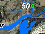
Little Elk Creek GPS Location 50

Location 50 is a site with historical buildings on the left bank of Little Elk Creek, approximately 150 m (1/10 of a mile) upstream from the confluence of Little and Big Elk Creeks.  The creek was at least 30 m (100 feet) wide and appeared to be tidally influenced.  The left bank slopes gently to the water and is fairly muddy; the right bank is near vertical and about 0.6 m (2 feet) tall.  The substrate is fine-grained. Phragmites dominated the right bank and mowed lawn dominated the left bank.  Trees form a riparian buffer further downstream where Big Elk Creek comes in from the left.

Click on an image below to see the full image.

Location 50 - Aerial View

Location 50 - Aerial View

Location 50 - Little Elk Creek just upstream of confluence with Big Elk Creek

Location 50 - Little Elk Creek just upstream of confluence with Big Elk Creek (1 of 2)

Location 50 - Signage at Elkton historical site

Location 50 - Signage at Elkton historical site

Location 50 - Little Elk Creek just upstream of confluence with Big Elk Creek

Location 50 - Little Elk Creek just upstream of confluence with Big Elk Creek (2 of 2)

Related Pages on Our Site
NOAA logo