Skip all menusSkip first menu
Environment Canada / Environnement Canada Canada
Français Contact Us Help Search Canada Site
What's New
About Us
Topics Publications Weather Home


Ramsar Sites
Whooping Crane Summer Range; Photo: B. Johns
Back to
Key Habitats
 

Quill Lakes, Saskatchewan - Ramsar Site

Overview (Principal Characteristics):

The Quill Lakes are the repository for an internal drainage basin which contains three distinct wetlands; Big Quill, Middle Quill (Mud Lake) and Little Quill lakes.

Reasons for Ramsar Designation:

Quill Lakes is one of the key breeding ground areas for North American populations of waterfowl and other migratory birds and shorebirds. The area is a major shorebird staging area in the spring and fall with numbers ranging from 60 000 to 155 000 birds.

Date of Ramsar Designation:

27 May 1987

Jurisdiction:

Provincial - Saskatchewan Environment (Fish and Wildlife Branch)

Land Tenure:

  • Site:

    The lake complex is principally provincial Crown land administered by the Government of Saskatchewan.

  • Surrounding Area:

    Mainly privately-held land.

Conservation Measures Taken:

18 000 ha have been designated under the Saskatchewan Critical Wildlife Habitat Protection Act. Islands located in Middle Quill Lake are designated as provincial wildlife refuges to protect breeding colonies of American White Pelican (Pelecanus erythorhynchos) and Double-crested Cormorant (Phalacrocorax auritus). The wetland complex is also included in the Saskatchewan Heritage Marsh Program. Quill Lakes was identified as a site under the International Biological Program in the 1970s. The site was declared a Western Hemispheric Shorebird Reserve in May 1994 under the Western Hemispheric Shorebird Reserve Network.

Conservation Measures Proposed:

None currently.

Current Land Use/Activities in:

  • Site:

    In 1987, Quill Lakes was used as the first implementation site for the North American Waterfowl Management Plan (NAWMP) in Canada. In NAWMP First Step initiatives alone, 6 630 ha were protected and or enhanced here for waterfowl and other wildlife values. Designation as a premier provincial marsh under the Heritage Marsh Program involves intensified management of existing Ducks Unlimited Canada projects on tributary drainages, and the allocation of more resources to the waterfowl crop damage prevention program.

    Agricultural activities (cultivation, livestock grazing and haying) have been common for most of the past century throughout upland areas associated with the Quill Lakes complex, and grazing and haying also occur on the salt flats of Big Quill Lake. The Waterfowl Crop Damage Control Program was instituted in the late 1960s to compensate landowners for grain crops lost to field feeding waterfowl. This active program now employs temporary lure crops (168 ha) and four bait stations to reduce the incidence of crop depredation in the area. Field studies indicated a need to upgrade the local crop damage control program; this is being done under the North American Waterfowl Management Plan activities in this region.

  • Surrounding Area:

    Mainly private agricultural land. Some lands are being managed for wildlife by the province of Saskatchewan (Fish and Wildlife Branch) and Saskatchewan Watershed Authority - Stewardship Division.

Threats to Integrity of:

  • Site:

    A potassium sulphate extraction plant has been proposed for Big Quill Lake. Concern over resultant water chemistry changes to the lake and potential associated impacts on aquatic invertebrates and migratory birds has resulted in an environmental impact assessment by the province of Saskatchewan. This assessment concluded that the proposed development would not have a significant impact on the ecology of the lake. Based upon the assessment, the proposed development has been approved. The Potash Corporation of Saskatchewan has been directed to monitor Piping Plover (Charadrius melodus circumcinctus) and other shorebird populations in advance of any decision to proceed.

    Drought has led to a serious drawdown in lake levels, resulting in increasing salinity levels and reduction in shoreline habitat for such species as Piping Plover.

  • Surrounding Area:

    None currently.

Status of Management Plan:

Numerous sites around the lakes are managed as waterfowl projects under the North American Waterfowl Management Plan.

Management Authority:

The area is managed in cooperation with the Saskatchewan Watershed Authority. The responsible management authority is:

Fish and Wildlife Branch
Saskatchewan Environment
3211 Albert Street
Regina, Saskatchewan
S4S 5W6

The Saskatchewan Watershed Authority
Park Plaza
Suite 420 - 2365 Albert Street
Regina, Saskathewan
S4P 4K1


| What's New | About Us | Topics | Publications | Weather | Home |
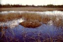
| Français | Contact Us | Help | Search | Canada Site |
The Green LaneTM, Environment Canada's World Wide Web site
Last updated: 2006-12-21
Last reviewed: 2006-12-21
URL of this page: http://www.pnr-rpn.ec.gc.ca /nature/whp/ramsar/df02s11.en.html