
Gilbert Islands
 The Gilbert Islands (Tungaru) are a group of 11 atolls and 5 islands located in the western regions
of the central Pacific, situated across the equator. The islands are located southwest of the
Marshall Islands and northwest of the islands and atolls that form the nation
of Tuvalu. Those islands and atolls that are located north of the equator are
referred to as the North Gilbert Islands, with those to the south being the South Gilbert Islands.
The Gilbert Islands (Tungaru) are a group of 11 atolls and 5 islands located in the western regions
of the central Pacific, situated across the equator. The islands are located southwest of the
Marshall Islands and northwest of the islands and atolls that form the nation
of Tuvalu. Those islands and atolls that are located north of the equator are
referred to as the North Gilbert Islands, with those to the south being the South Gilbert Islands.
The islands are one of the three central Pacific island groups that comprise the nation of Kiribati. The others being the Rawaki (Phoenix) Islands (800 km to the southeast) and the Line Islands (located over 3,000 km distant to the east). Also part of the nation of Kiribati is the isolated and solitary island of Banaba lying 600 km southwest of Tarawa. For administrative purposes Banaba is considered as one of the Gilbert Islands (treated here as a separate unit). In all, the widely scattered islands of Kiribati give the nation an Exclusive Economic Zone in the region of 3.5 million km².
The Gilbert Islands are the most populated group of islands within Kiribati. The atolls include: Abaiang (16 km²), Abemama (27.8 km²), Aranuka (15.5 km²), Beru (14.7 km²), Butaritari (13.6 km²), Maiana (16.7 km²), Marakei (13.5 km²), Nonouti (29.2 km²), Onotoa (13.5 km²), Tabiteuea (38 km²) and the main population centre of Tarawa (31.9 km²). The islands consist of: Arorae (7.6 km²), Kuria (12.7 km²), Makin (6.7 km²), Nikunau (18.2 km²) and Tamana (4.8 km²). The group — with a total land area of 282 km² — are all low-lying coral formations, vegetated with coconut palm, pandanus and atoll scrub.
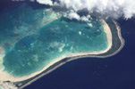
Most of the atolls found within the Gilbert Islands have similar morphologies: all are of similar size, all have their eastern sides being dominated by near continuous strips of land or closely spaced motu; western sides of the atolls consist mainly of submerged reef punctuated by passes.