Bathurst Island
- Terra MODIS
- 08 July 2003
- 03:15 UTC
Bathurst Island is the largest island of the Bathurst Island Group — a grouping that also includes the smaller offshore islands of Cameron Island, Île Vanier, Massey Island, Alexander Island, Helena Island and many smaller islands and islets. The islands form part of the Parry Islands subgroup of the Queen Elizabeth Islands. They are located in the western high Arctic region, east from Melville Island, northwest from Cornwallis Island and southwest from the Grinnell Peninsula of Devon Island. The total land area of the group amounts to over 18,000 km², with Bathurst Island itself covering 16,042 km².
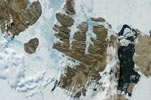
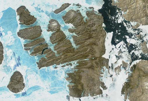
The islands exist in an area of highly folded limestone and sandstone bedrock known as the Parry Islands Fold Belt that extends westwards to Melville Island. Here, the geology is characterised by east to west trending anticlines. These formations come to an end on the eastern side of Bathurst Island where the north to south orientated Cornwallis Fold Belt is encountered. This transition is prominently marked in the above image — the rocks of the Cornwallis Fold Belt form a lighter-coloured band that runs along the eastern side of the island in contrast to the darker rocks of the west.
The topography is that of a relatively flat to undulating plateau with average elevations of between 100 m and 200 m above sea level. Greatest elevations are found in the far southeastern corner of the island where Peaked Hill rises to a height of 376 m and in the Stokes Range (380 m) — situated at the northern end of the central peninsula formed by May Inlet (on the east) and Erskine Inlet (west). Like many of the islands of the high Arctic zone, Bathurst presents a bleak landscape of bare rock and treeless stony plains. Despite this, areas of thin soil help to support a low-lying Arctic flora that provides the basis of a food chain sustaining a wide variety of Arctic fauna.
Bathurst Island has an irregular coastline that is marked by wide inlets, bays and peninsulas. The northern coastline is cut by three large channels that extend deep into the interior, almost trisecting the island. From east to west these are: Young Inlet, May Inlet, and Erskine Inlet; the western boundary to the latter being formed by the islands of Cameron, Vanier, Marc, Massey, and Alexander. The largest feature of the western coast is provided by Graham Moore Bay. Almost completely separating the southern half of Bathurst Island from the lands to the north, the bay penetrates through the Bracebridge Inlet and the mouth of the Caledonian River to reduce the islands width to just 25 km, where the Polar Bear Pass traverses the island to Goodsir Inlet on the east coast.
In addition to the main offshore islands already mentioned, many smaller islands are located off the southwest, southeast and northeast coasts. These include the elongate islands of the Graham Moore Bay and Bracebridge Inlet regions of the west coast, the islands scattered around the Gregory Peninsula on the southeast coast and the Berkeley Group of islands located at the head of Young Inlet in the north (Allard Island, Harwood Island, Ricards Island, and Sherard Osborn Island).
image: MODIS rapid response project at nasa/goddard space flight center
Location Map