
Brock Island
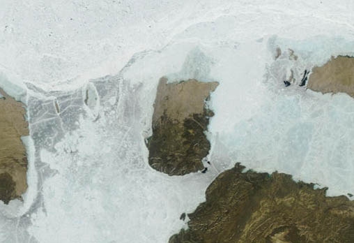
- Terra MODIS
- 01 August 2006
- 03:15 UTC
The westernmost and smallest of a cluster of three islands located at the northwestern edge of the Arctic Archipelago, Brock Island is located 6 km west from MacKenzie King Island (at bottom edge of the above image) and 34 km from the southwestern tip of Borden Island (at top-right). Also visible in the image (at left edge) is the northeastern tip of Prince Patrick Island, located 47 km to the southwest.
Brock Island has a very flat and featureless landscape with average elevations over much of the island being in the range 20-40 m; a maximum height of 67 m above sea level is reached in the south. Rectangular in shape, the island has an area 764 km², with dimension of 37 km by 22 km. In a similar fashion to the neighbouring Borden Island, the geology of Brock Island has two distinct halves: darker rocks on the southern half (slightly more elevated) are of the Innuitian Orogen, while the lighter-coloured rocks of the north are part of the Arctic Continental Shelf.
image: MODIS rapid response project at nasa/goddard space flight center
Location Map