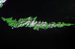
Amlia
- ISS005-E-18357
- 23 October 2002
- 23:50 UTC
Amlia Island (445 km²) is located near the eastern end of the Andreanof Islands group, located less than 2 km across the Amlia Pass from the island of Atka; the western end of Amlia forms part of the southern boundary to Atka's large Nazen Bay. Off the eastern end of Amlia, 29 km to the northeast across the Seguam Pass, is the island of Seguam.
The east to west orientated island is elongate in form, with a length of 74 km; widths across the island vary from as little as just a few hundred metres in the east to 8 km in the central regions. The island has a maximum elevation of 639 m above sea level.
image: earth sciences and image analysis laboratory, nasa johnson space center
Location Map