Attu
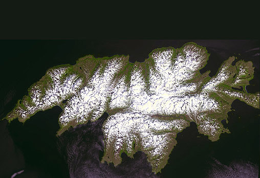
- Terra ASTER
- 04 July 2000
At 893 km² in area, Attu is the largest member of the Near Islands group, situated at the western end of the Aleutian chain, some 725 km east from the Kamchatka Peninsula in the Russian Far East. It is separated from the rest of the Near Islands (Agattu and the Semichi Islands) by the Agattu Strait, with Agattu being 37 km to the southeast and the Semichi Islands 29 km to the east. The island's western tip at Cape Wrangel is the westernmost point of Alaska — the next landfall on the Aleutian Arc is at the Komandor Islands, 344 km to the northwest.
The island, which has a mountainous interior rising to 860 m, measures 56 km in length (east to west) and is up to 32 km in width.
image: image: nasa/gsfc/meti/ersdac/jaros, and us/japan ASTER science team
Location Map