Kagalaska

- ISS005-E-18349
- 23 October 2002
- 23:49 UTC
Kagalaska is situated midway along the Andreanof Islands group, and lies immediately east from the island of Adak — from which it is separated by the narrow Kagalaska Strait. The northern shores of the island face the Sitkin Sound — a semi-enclosed bay formed by Adak (on the west) Great Sitkin (on the northeast) and by Little Tanaga and Umak (on the southeast).
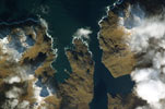
The above image is centred on the Kagalaska Strait. The Laska Cove region of western Kagalaska is on the right with the Blind Point and Blind Bight region of northeastern Adak on the left
The 116 km² island has dimensions of 14.5 km in length and 11.3 km in width. The eastern shore of the island is marked by several narrow inlets and bays separated by mountainous ridges — Quail Bay and Crater Cove in the southeast and by the Upper and Lower Arms of Cabin Cove in the northeast — creating a convoluted and irregular coastline. Terrain consists of three broad zones: mountains in the north and south and a lower-lying region of lakes and rivers in the centre. The interior mountains are at their highest in the northern sector, reaching a maximum of 760 m above sea level.
image: earth sciences and image analysis laboratory, nasa johnson space center
Location Map