
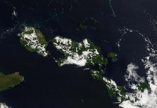
D'Entrecasteaux Islands
- MODIS image
- date unknown
A major island group of the Milne Bay province of southeastern Papua New Guinea, the D'Entrecasteaux Islands are located off the northern coast of the southern sections of the Papuan Peninsula. They are separated from the mainland (partially visible at the left edge of the above image) by the 30 km wide Ward Hunt Strait in the north and by the 18 km wide Goschen Strait in the south.
The islands of the D'Entrecasteaux group are arranged in a northwest to southeast trending line, spanning across a distance of nearly 160 km. They are a continuation of the Central Cordillera mountain range that runs through central New Guinea. As the range passes through New Guinea it becomes lower towards the southeast, eventually forming the Owen Stanley Range, the Papuan Peninsula, the islands of the D'Entrecasteaux group and the Louisiade Archipelago.
There are three main islands (top-left to bottom-right in the image): Goodenough Island (687 km²), Fergusson Island (1,437 km²), and Normanby Island (1,040 m²). The islands are mountainous with peaks rising to over 2,000 m above sea level — a maximum elevation of 2,536 m is reached at the peak of Mount Vineuo on Goodenough Island. The islands are hydrothermally active with hot-springs and geysers.
In addition to the three main islands there are also numerous smaller offshore islands and island groups (see large size image) that bring the total land area of the group to around 3,110 km². The largest of the minor islands is that of Sanaroa, located off the southeastern side of Fergusson Island. Other islands include the 18 islands of the Amphlett Group (northeast from Fergusson), Wagipa (in the Moresby Strait, between Fergusson and Goodenough islands), and the islands of Doba, Nekumara, and Kwaiope (off the nothern peninsula of Normanby Island). From the northern shore of Goodenough Island an extensive region of small reefs extends to the north and east.
image: MODIS rapid response project at nasa/goddard space flight center
Location Map
