
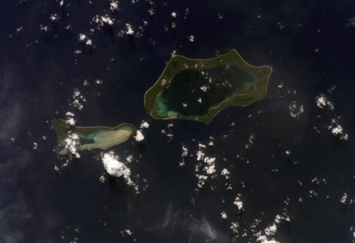
Green Islands
- ISS014-E-18842
- 02 April 2007
- 22:04 UTC
The Green Islands (Nissan Islands) lie 63 km northwest from the Buka-Bougainville pair, 58 km southeast of the Feni Islands (see panoramic image) and 110 km east from New Ireland. They are part of the island arc system that emerges from the northern end of the Solomon chain and runs parallel to New Ireland for over 600 km. The group is composed of two units: Nissan and Pinipel, separated by around 2 km.
Nissan (at right in the image) is a raised atoll-like structure (measuring 15 km in length and with a maximum width of 8 km) composed of several islands that enclose a central lagoon of 20 m to 60 m in depth. Only the main island of Nissan (which once lent its name to the group) is visible in this image, wrapping around the northern, eastern, southern and southwestern sides of the formation. The smaller islands of Barahun and Sirot are located on the northwestern side — formed where the South, Middle and North Channels connect the lagoon waters with those of the open ocean. At the lagoon centre lies the small islet of Hon. The seaward side of the islands are lined with low cliffs of up to 60 m in height.
image: earth sciences and image analysis laboratory, nasa johnson space center
Location Map

