
Gawa
- Landsat 7
- Path 093 Row 066
- 16 May 2001
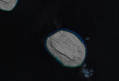
The island of Gawa lies in the Solomon Sea region of southeastern Papua New Guinea, situated between the Woodlark Islands (41 km to the east) and the Trobriand Islands (83 km to the west). Its immediate neighbours include Egum Atoll 31 km to the southwest, and Kwaiawata 5 km to the northwest (partially visible at the top-left corner of the above false colour image). The island is part of the Marshall Bennett Islands group (Dugumenu, Gawa, Iwa, and Kwaiawata).
Gawa, the easternmost and largest island of the Marshall Bennett group, is an oval-shaped island of 5 km by 3 km. The island shows evidence of having been geologically uplifted in the past; probably a former atoll formation, the former reef rim now stands as a steep to vertical escarpment that rises to a flat-topped plateau (the former lagoon floor) within the interior. A narrow fringing reef surrounds the entire island.
image: millenium coral reefs landsat archive/usf millenium global coral reef mapping project/nasa seawifs/nasa jsc
Location Map