
Narage
- Terra ASTER
- 31 July 2000
- 00:44 UTC
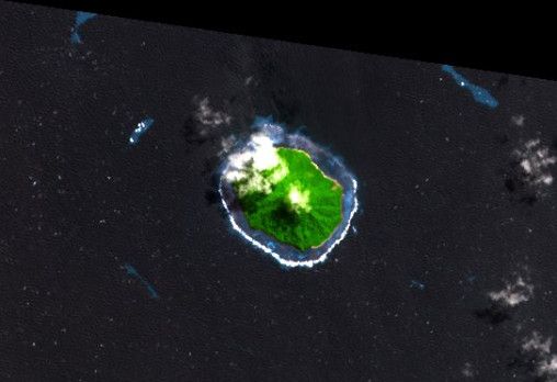
The small island of Narage lies within the south-central regions of the Bismarck Sea. It is a member of the Vitu Islands group — a grouping located between 60 km and 100 km north from the coast of New Britain. Narage, the northernmost of the Vitu Islands, is situated 34 km north from Unea and 23 km northwest from Mundua.
The island takes the form of a small cone — Narage is a stratovolcano, last active during the Pleistocene — that rises to a height of 307 m above sea level. Today, the only signs of volcanic activity are the hot springs found on the south coast. A fringing reef encircles the island at a distance of 200 m to 400 m, enclosing a narrow lagoon.
Within the vicinity of Narage are many small reefs, all of which are submerged, including a chain of reefs that extends to the southwest for around 12 km (see panoramic image).
Synonyms: Gipps Island, Narage, Narega, Narraga, Narrage, Nord Island, North Island
image: ASTER volcano archive jpl/nasa
Location Map
